Clear fishing map is available as part of iBoating : USA Marine & Fishing App(now supported on multiple platforms including Android, iPhone/iPad, MacBook, and Windows(tablet and phone)/PC based chartplotter.).
With our Lake Maps App, you get all the great marine chart app features like fishing spots, along with Clear lake depth map. The fishing maps app include HD lake depth contours, along with advanced features found in Fish Finder / Gps Chart Plotter systems, turning your device into a Depth Finder. The Clear Navigation App provides advanced features of a Marine Chartplotter including adjusting water level offset and custom depth shading. Fishing spots and depth contours layers are available in most Lake maps. Lake navigation features include advanced instrumentation to gather wind speed direction, water temperature, water depth, and accurate GPS with AIS receivers(using NMEA over TCP/UDP). Autopilot support can be enabled during ‘Goto WayPoint’ and ‘Route Assistance’.
Now i-Boating supports Fishing Points in Clear.
Have more questions about the Nautical Chart App? Ask us.
Fishing Info for Clear
Clear Lake is a lake in Meeker County, in the U.S. state of Minnesota. Clear Lake was named on account of its clear water. Clear Lake is 529 acres and reaches a maximum depth of 18 feet and average 10 feet in depth. The lake generally has cloudy water, which averages around 2 feet in clarity. Eurasian watermilfoil was found in Clear Lake in 2013. Clear Lake is known for its large bullhead and panfish populations and is heavily fished for walleye.
More on Wikipedia...Popular fish species in this lake include Ameiurus, Panfish and Walleye.
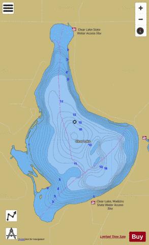
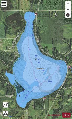
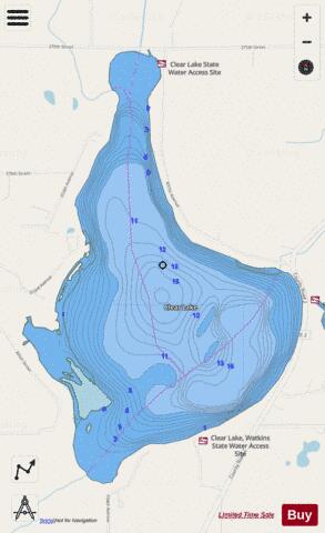
Clear Fishing Map Stats | |
| Title | Clear |
| Scale | 1:6000 |
| Counties | Meeker |
| Nearby Cities | Watkins, Forest City, Saint Nicholas, Eden Valley, Kimball, Kingston, Litchfield, Manannah, Cold Spring, Darwin |
| Area * | 529.32 acres |
| Shoreline * | 6.59 miles |
| Min Longitude | -94.46 |
| Min Latitude | 45.26 |
| Max Longitude | -94.43 |
| Max Latitude | 45.29 |
| Edition Label 1 | |
| Edition Label 2 | |
| Edition Label 3 | |
| Id | US_MN_47009500 |
| Country | US |
| Projection | Mercator |
| * some Stats may include nearby/connecting waterbodies | |
|