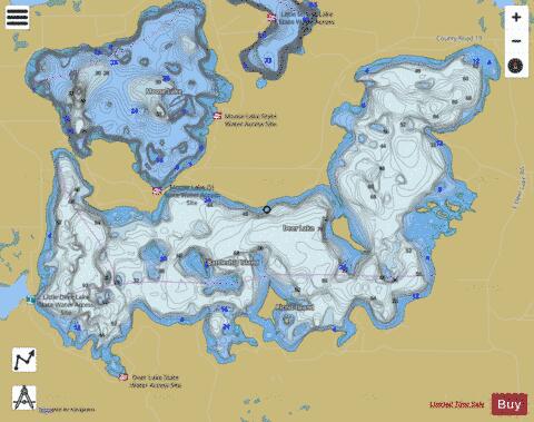
Deer fishing map is available as part of iBoating : USA Marine & Fishing App(now supported on multiple platforms including Android, iPhone/iPad, MacBook, and Windows(tablet and phone)/PC based chartplotter.).
With our Lake Maps App, you get all the great marine chart app features like fishing spots, along with Deer lake depth map. The fishing maps app include HD lake depth contours, along with advanced features found in Fish Finder / Gps Chart Plotter systems, turning your device into a Depth Finder. The Deer Navigation App provides advanced features of a Marine Chartplotter including adjusting water level offset and custom depth shading. Fishing spots and depth contours layers are available in most Lake maps. Lake navigation features include advanced instrumentation to gather wind speed direction, water temperature, water depth, and accurate GPS with AIS receivers(using NMEA over TCP/UDP). Autopilot support can be enabled during ‘Goto WayPoint’ and ‘Route Assistance’.
Now i-Boating supports Fishing Points in Deer.
Have more questions about the Nautical Chart App? Ask us.
Fishing Info for Deer
Deer Lake is located in Itasca County, Minnesota about 12 miles (19 km) north of Grand Rapids and about 8 miles (13 km) northeast of Deer River. The lake covers 4,156 acres (17 km2) and is roughly 5 miles (8 km) long and 1.5 mi (2.4 km) wide. Deer Lake is fed by three sources: rainfall, underwater springs, and one inlet from Little Deer Lake. It belongs to a chain of pristine lakes, feeding Bay Lake - headwaters of the mighty Deer River (namesake of the town) which feeds White Oak Lake (part of the Mississippi River). Otter, Moose, Little Moose, Fawn, and Cottonwood Lakes also feed Bay Lake. Often called the "Lake of the Changing Colors", Deer Lake's crystal-clear water displays a wide range of magnificent colors on sunny days - divulging the locations of its perilous rockbars to unfamiliar boaters. While Deer Lake ranks among the clearest lakes of Minnesota, what distinguishes it from its peers is its many interesting islands. In 1998, the DNR and Deer Lake Association jointly acquired Bear Island to preserve its undeveloped charm. Although bears are rarely (if ever) seen on the island, the presence of an inactive eagle's nest in a large white pine makes the island a popular destination for observing wildlife. Other notable islands include Battleship Island, Star (also known as Picnic) Island, and many others lacking agreed-upon names. A plethora of wildlife make Deer Lake their abode. The lake's healthy fish population includes several species of muskie, northern pike, walleye, perch, bluegills, sunfish, rock bass, crappie, and largemouth and smallmouth bass. On its surface swim several happy loon families, a variety of ducks, and the Canada goose. This is ranked as one of the clearest lakes located in Minnesota with a water clarity level of 16 feet (5 m). Deer Lake is an English translation of the native Ojibwe-language name Waawaashkeshiwi-zaaga'igan, meaning "lake of the deer."
More on Wikipedia...Popular fish species in this lake include Crappie, Largemouth bass, Northern pike, Rock bass, Smallmouth bass and Walleye.
Deer Fishing Map Stats | |
| Title | Deer |
| Scale | 1:12000 |
| Counties | Itasca |
| Nearby Cities | Zemple, Deer River, Cohasset, Grand Rapids, Marcell, La Prairie, Coleraine, Bovey, Ball Club, Taconite |
| Area * | 4097.24 acres |
| Shoreline * | 26.11 miles |
| Min Longitude | -93.71 |
| Min Latitude | 47.36 |
| Max Longitude | -93.62 |
| Max Latitude | 47.40 |
| Edition Label 1 | |
| Edition Label 2 | |
| Edition Label 3 | |
| Id | US_MN_31071900 |
| Country | US |
| Projection | Mercator |
| * some Stats may include nearby/connecting waterbodies | |
|


