Bemidji (main lake) fishing map is available as part of iBoating : USA Marine & Fishing App(now supported on multiple platforms including Android, iPhone/iPad, MacBook, and Windows(tablet and phone)/PC based chartplotter.).
With our Lake Maps App, you get all the great marine chart app features like fishing spots, along with Bemidji (main lake) depth map. The fishing maps app include HD lake depth contours, along with advanced features found in Fish Finder / Gps Chart Plotter systems, turning your device into a Depth Finder. The Bemidji (main lake) Navigation App provides advanced features of a Marine Chartplotter including adjusting water level offset and custom depth shading. Fishing spots and depth contours layers are available in most Lake maps. Lake navigation features include advanced instrumentation to gather wind speed direction, water temperature, water depth, and accurate GPS with AIS receivers(using NMEA over TCP/UDP). Autopilot support can be enabled during ‘Goto WayPoint’ and ‘Route Assistance’.
Now i-Boating supports Fishing Points in Bemidji (main lake).
Have more questions about the Nautical Chart App? Ask us.
Fishing Info for Bemidji (main lake)
Lake Bemidji is a small glacially-formed lake, approximately 11 square miles (28,000,000 m2; 7,000 acres; 2,800 ha) in area, in northern Minnesota in the United States. Located less than 50 miles (80 km) downstream from the source of the Mississippi River, it both receives and is drained by the Mississippi.
More on Wikipedia...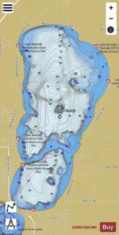
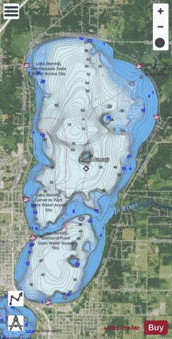
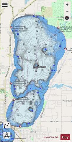
Bemidji (main lake) Fishing Map Stats | |
| Title | Bemidji (main lake) |
| Scale | 1:12000 |
| Counties | Beltrami |
| Nearby Cities | Bemidji, Lavinia, Turtle River, Wilton, Puposky, Guthrie, Tenstrike, Becida, Hines, Cass Lake |
| Area * | 6582.71 acres |
| Shoreline * | 15.42 miles |
| Min Longitude | -94.88 |
| Min Latitude | 47.46 |
| Max Longitude | -94.82 |
| Max Latitude | 47.54 |
| Edition Label 1 | |
| Edition Label 2 | |
| Edition Label 3 | |
| Id | US_MN_04013002 |
| Country | US |
| Projection | Mercator |
| * some Stats may include nearby/connecting waterbodies | |
|