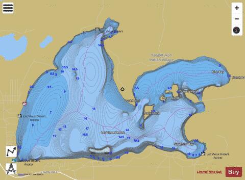
Lac Vieux Desert fishing map is available as part of iBoating : USA Marine & Fishing App(now supported on multiple platforms including Android, iPhone/iPad, MacBook, and Windows(tablet and phone)/PC based chartplotter.).
With our Lake Maps App, you get all the great marine chart app features like fishing spots, along with Lac Vieux Desert depth map. The fishing maps app include HD lake depth contours, along with advanced features found in Fish Finder / Gps Chart Plotter systems, turning your device into a Depth Finder. The Lac Vieux Desert Navigation App provides advanced features of a Marine Chartplotter including adjusting water level offset and custom depth shading. Fishing spots and depth contours layers are available in most Lake maps. Lake navigation features include advanced instrumentation to gather wind speed direction, water temperature, water depth, and accurate GPS with AIS receivers(using NMEA over TCP/UDP). Autopilot support can be enabled during ‘Goto WayPoint’ and ‘Route Assistance’.
Now i-Boating supports Fishing Points in Lac Vieux Desert.
Have more questions about the Nautical Chart App? Ask us.
Fishing Info for Lac Vieux Desert
Lac Vieux Desert is a lake in the United States divided between Gogebic County, Michigan, and Vilas County, Wisconsin. Fed primarily by springs in the surrounding swamps, it is the source of the Wisconsin River, which flows out of its southwest corner. The lake contains a number of small islands, especially in its northeastern lobe, including Draper Island in Michigan and Duck Island, in Wisconsin. Lac Vieux Desert has a surface elevation 1,680 ft (510 m) above sea level, and a maximum depth of about 40 ft (12 m). The surface area is 4,260 acres (17.24 km2; 6.66 sq mi), of which approximately two-thirds is in Wisconsin and one third in Michigan. Located in the Lake District of northern Wisconsin, the lake is a popular boating and fishing resort. The lake was named by French fur trappers, who were some of the first Europeans in the region. They translated the name into French from the term used by the Ojibwe of the area: Gete-gitigaani-zaaga'igan, meaning "Lake of the Old Clearing", or "Old Garden." At the time of European colonization, the Ojibwe (also known in the US as Chippewa) occupied extensive territory around Lake Superior, in what are now the jurisdictions of northern Michigan, Wisconsin and Minnesota in the United States, and northern Ontario through southeastern Manitoba in Canada. The Michigan shore of Lac Vieux Desert is in the largest of the few small areas of Michigan that are part of the drainage or watershed of the Mississippi River. There are three such areas along the Wisconsin border with Gogebic County and a bit of Iron County in the Upper Peninsula of Michigan, and two areas along the Indiana border with Berrien County in southern Michigan.
More on Wikipedia...Popular fish species in this lake include Tiger muskellunge.
Lac Vieux Desert Fishing Map Stats | |
| Title | Lac Vieux Desert |
| Scale | 1:24000 |
| Includes Data from Fish Atlas | Yes |
| Counties | Gogebic, Vilas |
| Nearby Cities | Phelps, Land O' Lakes, Watersmeet, Conover, Eagle River, Clearwater Lake, Alvin, Three Lakes, Trout Creek, Sugar Camp |
| Area * | 4370.13 acres |
| Shoreline * | 19.34 miles |
| Min Longitude | -89.15 |
| Min Latitude | 46.12 |
| Max Longitude | -89.06 |
| Max Latitude | 46.16 |
| Edition Label 1 | |
| Edition Label 2 | |
| Edition Label 3 | |
| Id | US_MI_27_3 |
| Country | US |
| Projection | Mercator |
| * some Stats may include nearby/connecting waterbodies | |
|


