Toddy Pond fishing map is available as part of iBoating : USA Marine & Fishing App(now supported on multiple platforms including Android, iPhone/iPad, MacBook, and Windows(tablet and phone)/PC based chartplotter.).
With our Lake Maps App, you get all the great marine chart app features like fishing spots, along with Toddy Pond depth map. The fishing maps app include HD lake depth contours, along with advanced features found in Fish Finder / Gps Chart Plotter systems, turning your device into a Depth Finder. The Toddy Pond Navigation App provides advanced features of a Marine Chartplotter including adjusting water level offset and custom depth shading. Fishing spots and depth contours layers are available in most Lake maps. Lake navigation features include advanced instrumentation to gather wind speed direction, water temperature, water depth, and accurate GPS with AIS receivers(using NMEA over TCP/UDP). Autopilot support can be enabled during ‘Goto WayPoint’ and ‘Route Assistance’.
Now i-Boating supports Fishing Points in Toddy Pond.
Have more questions about the Nautical Chart App? Ask us.
Fishing Info for Toddy Pond
Toddy Pond is a narrow lake, eight-miles long, in Hancock County, Maine. South Toddy leads from Surry and Blue Hill townships via a narrow channel to Middle Toddy that is edged by Surry and Penobscot townships. All of North Toddy, which is connected to Middle Toddy by another narrow channel, lies in Orland township. U.S. Route One crosses the northern end of the lake, paralleling the dam through which the waters of Toddy Pond flow down to Alamoosook Lake and thence eventually to the Penobscot River. A public boat landing is located off Route One. The cold water of North Toddy is home to a self-sustaining population of lake trout; it is also stocked with splake, brown trout, and land-locked Atlantic salmon. Smallmouth bass and white perch thrive in the warmer water of Middle and South Toddy. In spring the lake is a spawning venue for alewife. The Toddy Pond Association was established in 1999 by concerned property owners in order to protect the lake and its watershed and educate members about relevant environmental issues.
More on Wikipedia...Popular fish species in this lake include Atlantic salmon, Lake trout and Smallmouth bass.
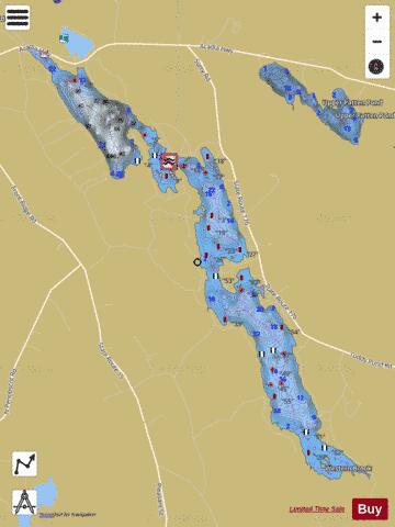
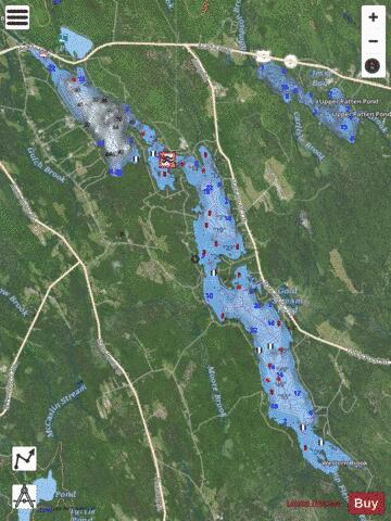
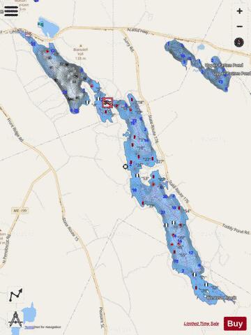
Toddy Pond Fishing Map Stats | |
| Title | Toddy Pond |
| Scale | 1:12000 |
| Counties | Hancock |
| Nearby Cities | Orland, Blue Hill, Surry, Penobscot, Bucksport, Dedham, Green Lake, Brooksville, Ellsworth, Sedgwick |
| Area * | 2410.38 acres |
| Shoreline * | 31.29 miles |
| Min Longitude | -68.68 |
| Min Latitude | 44.48 |
| Max Longitude | -68.58 |
| Max Latitude | 44.57 |
| Edition Label 1 | |
| Edition Label 2 | |
| Edition Label 3 | |
| Id | US_ME_01773778 |
| Country | US |
| Projection | Mercator |
| * some Stats may include nearby/connecting waterbodies | |
|