Scopan Lake fishing map is available as part of iBoating : USA Marine & Fishing App(now supported on multiple platforms including Android, iPhone/iPad, MacBook, and Windows(tablet and phone)/PC based chartplotter.).
With our Lake Maps App, you get all the great marine chart app features like fishing spots, along with Scopan Lake depth map. The fishing maps app include HD lake depth contours, along with advanced features found in Fish Finder / Gps Chart Plotter systems, turning your device into a Depth Finder. The Scopan Lake Navigation App provides advanced features of a Marine Chartplotter including adjusting water level offset and custom depth shading. Fishing spots and depth contours layers are available in most Lake maps. Lake navigation features include advanced instrumentation to gather wind speed direction, water temperature, water depth, and accurate GPS with AIS receivers(using NMEA over TCP/UDP). Autopilot support can be enabled during ‘Goto WayPoint’ and ‘Route Assistance’.
Now i-Boating supports Fishing Points in Scopan Lake.
Have more questions about the Nautical Chart App? Ask us.
Fishing Info for Scopan Lake
Scopan Lake is a "V" shaped lake in northern Maine. The lake was known as Squa Pan Lake by early European settlers, but was renamed in 2011 to eliminate what Native Americans in the United States interpreted as a racial slur. The lake is mostly in Scopan township (formerly Squapan township), but the north end of the eastern arm of the "V" extends into Maine township 11, range 4; and the north end of the western arm extends into Masardis and Ashland. The lake discharges to Scopan Stream (formerly Squa Pan Stream) through a dam in Masardis. Scopan Stream flows into the Aroostook River 4 miles (6.4 km) downstream of the dam, and the Aroostook River is a tributary to the Saint John River. The Bangor and Aroostook Railroad crosses the northern tip of both arms of the lake.
More on Wikipedia...Popular fish species in this lake include Brook trout and Rainbow smelt.
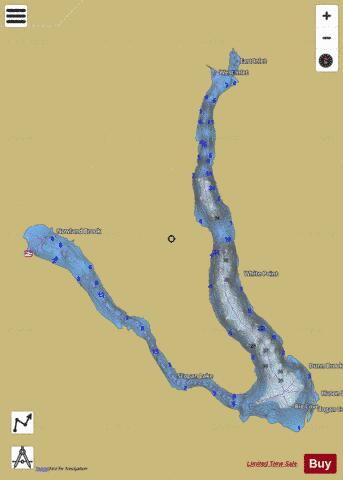
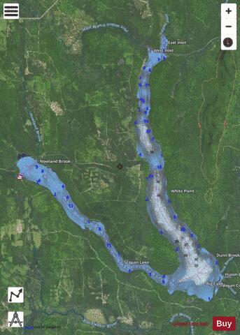
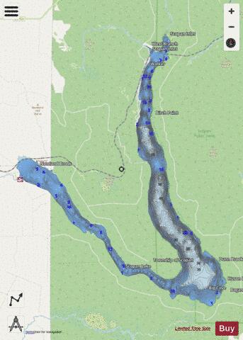
Scopan Lake Fishing Map Stats | |
| Title | Scopan Lake |
| Scale | 1:12000 |
| Counties | Aroostook |
| Nearby Cities | Masardis, Chapman, Mapleton, Ashland, Frenchville, Washburn, Oxbow, Presque Isle, Perham, Portage |
| Area * | 4976.16 acres |
| Shoreline * | 38.62 miles |
| Min Longitude | -68.33 |
| Min Latitude | 46.50 |
| Max Longitude | -68.19 |
| Max Latitude | 46.62 |
| Edition Label 1 | |
| Edition Label 2 | |
| Edition Label 3 | |
| Id | US_ME_00576172 |
| Country | US |
| Projection | Mercator |
| * some Stats may include nearby/connecting waterbodies | |
|