Rangeley Lake fishing map is available as part of iBoating : USA Marine & Fishing App(now supported on multiple platforms including Android, iPhone/iPad, MacBook, and Windows(tablet and phone)/PC based chartplotter.).
With our Lake Maps App, you get all the great marine chart app features like fishing spots, along with Rangeley Lake depth map. The fishing maps app include HD lake depth contours, along with advanced features found in Fish Finder / Gps Chart Plotter systems, turning your device into a Depth Finder. The Rangeley Lake Navigation App provides advanced features of a Marine Chartplotter including adjusting water level offset and custom depth shading. Fishing spots and depth contours layers are available in most Lake maps. Lake navigation features include advanced instrumentation to gather wind speed direction, water temperature, water depth, and accurate GPS with AIS receivers(using NMEA over TCP/UDP). Autopilot support can be enabled during ‘Goto WayPoint’ and ‘Route Assistance’.
Now i-Boating supports Fishing Points in Rangeley Lake.
Have more questions about the Nautical Chart App? Ask us.
Fishing Info for Rangeley Lake
Rangeley Lake, located in Franklin County, Maine in the United States, is fed by several streams. Its waters flow out from the lake's northwestern corner via the short Rangeley River into Mooselookmeguntic Lake, then Upper and Lower Richardson Lakes, Umbagog Lake and ultimately into the Androscoggin River, Merrymeeting Bay, the lower Kennebec River, the Gulf of Maine and the Atlantic Ocean. The lake is one of the major headwater lakes of the Androscoggin watershed. Its elevation is 1,518 feet (463 m) above sea level, and its area is about 10 square miles (26 km2). The lake's depth is shallow near the shore, with a central basin averaging about 95 feet (29 m) deep. The maximum depth is 149 feet (45 m). The lake is primarily in the town of Rangeley, while the southern edge of the lake is in unincorporated Rangeley Plantation. The village of Rangeley is located on the northeastern shore of Rangeley Lake, at City Cove, while the village of Oquossoc is at the lake's outlet at its northwest end. Maneskootuk Island (also called Doctors Island) is in the eastern part of Rangeley Lake. In the western part there is a small group of islands collectively called South Bog Islands.
More on Wikipedia...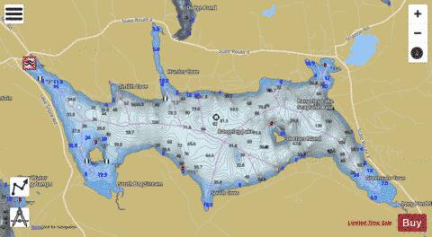
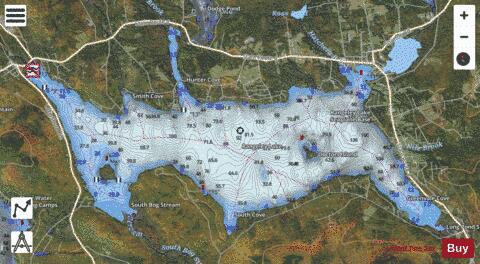
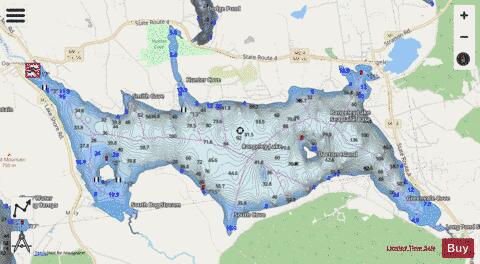
Rangeley Lake Fishing Map Stats | |
| Title | Rangeley Lake |
| Scale | 1:12000 |
| Counties | Franklin |
| Nearby Cities | Rangeley, Oquossoc, Byron, Roxbury, Wilsons Mills, Stratton, Andover, Phillips, Weld, Eustis |
| Area * | 6304.06 acres |
| Shoreline * | 32.59 miles |
| Min Longitude | -70.77 |
| Min Latitude | 44.92 |
| Max Longitude | -70.62 |
| Max Latitude | 44.98 |
| Edition Label 1 | |
| Edition Label 2 | |
| Edition Label 3 | |
| Id | US_ME_00574039 |
| Country | US |
| Projection | Mercator |
| * some Stats may include nearby/connecting waterbodies | |
|