Jordan Pond fishing map is available as part of iBoating : USA Marine & Fishing App(now supported on multiple platforms including Android, iPhone/iPad, MacBook, and Windows(tablet and phone)/PC based chartplotter.).
With our Lake Maps App, you get all the great marine chart app features like fishing spots, along with Jordan Pond depth map. The fishing maps app include HD lake depth contours, along with advanced features found in Fish Finder / Gps Chart Plotter systems, turning your device into a Depth Finder. The Jordan Pond Navigation App provides advanced features of a Marine Chartplotter including adjusting water level offset and custom depth shading. Fishing spots and depth contours layers are available in most Lake maps. Lake navigation features include advanced instrumentation to gather wind speed direction, water temperature, water depth, and accurate GPS with AIS receivers(using NMEA over TCP/UDP). Autopilot support can be enabled during ‘Goto WayPoint’ and ‘Route Assistance’.
Now i-Boating supports Fishing Points in Jordan Pond.
Have more questions about the Nautical Chart App? Ask us.
Fishing Info for Jordan Pond
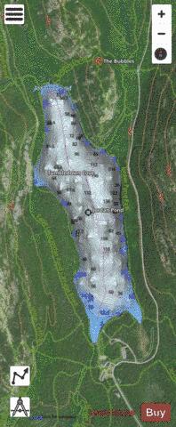
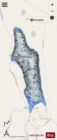
Jordan Pond is an oligotrophic tarn in Acadia National Park near the town of Bar Harbor, Maine. The pond covers 187 acres (76 ha) to a maximum depth of 150 feet (46 m) with a shoreline of 3.6 miles (5.8 km). The pond was formed by the Wisconsin Ice Sheet during the last glacial period. Penobscot Mountain (1194 ft) rises to the west, while Pemetic Mountain (1247 ft) rises to the east. Two roche moutonnées known as The Bubbles (North and South) rise above the northeastern shoreline. The southern end is constrained by glacial debris and an artificial dam. The pond has clear water, with visibility normally 44 feet (13.4 m) and occasionally recorded up to 61 feet (18.6 m), the deepest recordings in Maine. The pond exhibits high levels of dissolved oxygen, and low levels of plant nutrients and plant life. Some types of boating are permitted, but people and pets are prohibited from entering the water as it is the water supply for the village of Seal Harbor.
More on Wikipedia...Popular fish species in this lake include American eel, Atlantic salmon, Brook trout, Lake trout, Pumpkinseed, Rainbow smelt and Three-spined stickleback.
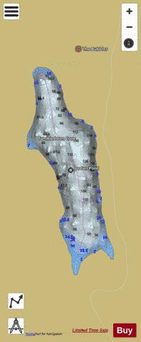
Jordan Pond Fishing Map Stats | |
| Title | Jordan Pond |
| Scale | 1:3000 |
| Counties | Hancock |
| Nearby Cities | Bar Harbor, Cranberry Isles, Somesville, Southwest Harbor, Bass Harbor, Trenton, Sorrento, Tremont, Winter Harbor, Hancock |
| Area * | 186.57 acres |
| Shoreline * | 3.12 miles |
| Min Longitude | -68.26 |
| Min Latitude | 44.32 |
| Max Longitude | -68.25 |
| Max Latitude | 44.34 |
| Edition Label 1 | |
| Edition Label 2 | |
| Edition Label 3 | |
| Id | US_ME_00568994 |
| Country | US |
| Projection | Mercator |
| * some Stats may include nearby/connecting waterbodies | |
|