Ellis Pond fishing map is available as part of iBoating : USA Marine & Fishing App(now supported on multiple platforms including Android, iPhone/iPad, MacBook, and Windows(tablet and phone)/PC based chartplotter.).
With our Lake Maps App, you get all the great marine chart app features like fishing spots, along with Ellis Pond depth map. The fishing maps app include HD lake depth contours, along with advanced features found in Fish Finder / Gps Chart Plotter systems, turning your device into a Depth Finder. The Ellis Pond Navigation App provides advanced features of a Marine Chartplotter including adjusting water level offset and custom depth shading. Fishing spots and depth contours layers are available in most Lake maps. Lake navigation features include advanced instrumentation to gather wind speed direction, water temperature, water depth, and accurate GPS with AIS receivers(using NMEA over TCP/UDP). Autopilot support can be enabled during ‘Goto WayPoint’ and ‘Route Assistance’.
Now i-Boating supports Fishing Points in Ellis Pond.
Have more questions about the Nautical Chart App? Ask us.
Fishing Info for Ellis Pond
Ellis Pond, also known as Silver Lake and Roxbury Pond, is a 919 acres (372 ha) glacial lake in Roxbury, Maine and partially in Byron, Maine, United States. It contains two islands, the bigger being named French Island, and the smaller unnamed. It also contains three small islets, the biggest of which is informally referred to as Loony Island, due to loons nesting there. It is fed by the and various smaller, unnamed streams, brooks, and rivers, and is drained by Ellis River. In 1940, the pond was estimated to be 920 acres (370 ha) in size, and in 1869, it was estimated to be 1.25 square miles (800 acres) in size.
More on Wikipedia...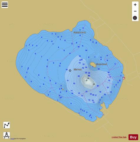
Ellis Pond Fishing Map Stats | |
| Title | Ellis Pond |
| Scale | 1:6000 |
| Counties | Oxford |
| Nearby Cities | Andover, Byron, Roxbury, Mexico, Rumford, Hanover, Carthage, Newry, Dixfield, Weld |
| Area * | 919.35 acres |
| Shoreline * | 5.60 miles |
| Min Longitude | -70.69 |
| Min Latitude | 44.65 |
| Max Longitude | -70.66 |
| Max Latitude | 44.67 |
| Edition Label 1 | |
| Edition Label 2 | |
| Edition Label 3 | |
| Id | US_ME_00565858 |
| Country | US |
| Projection | Mercator |
| * some Stats may include nearby/connecting waterbodies | |
|