Lake Buel fishing map is available as part of iBoating : USA Marine & Fishing App(now supported on multiple platforms including Android, iPhone/iPad, MacBook, and Windows(tablet and phone)/PC based chartplotter.).
With our Lake Maps App, you get all the great marine chart app features like fishing spots, along with Lake Buel depth map. The fishing maps app include HD lake depth contours, along with advanced features found in Fish Finder / Gps Chart Plotter systems, turning your device into a Depth Finder. The Lake Buel Navigation App provides advanced features of a Marine Chartplotter including adjusting water level offset and custom depth shading. Fishing spots and depth contours layers are available in most Lake maps. Lake navigation features include advanced instrumentation to gather wind speed direction, water temperature, water depth, and accurate GPS with AIS receivers(using NMEA over TCP/UDP). Autopilot support can be enabled during ‘Goto WayPoint’ and ‘Route Assistance’.
Now i-Boating supports Fishing Points in Lake Buel.
Have more questions about the Nautical Chart App? Ask us.
Fishing Info for Lake Buel
Lake Buel is a 196-acre (0.79 km2) great pond in Berkshire County, Massachusetts just south of Route 57 and east of Great Barrington. It is surrounded by over one-hundred summer homes and a few dozen year-round homes in about a dozen separate, tight-knit neighborhoods, each with its own private or semi-private road. The roads do not interlink. The lake is named after Samuel C. Buel of Tyringham, Massachusetts who saved people from drowning on the lake (called at the time Six Mile Pond) on July 23, 1812. The northern shore of the lake is in the town of Monterey and the southern shore is in New Marlborough. There is a paved boat ramp on the northwest shore owned by the and managed by and . A portion of the Appalachian Trail crosses over a breached mill dam along the northern inlet.
More on Wikipedia...Popular fish species in this lake include Black crappie, Brook trout, Brown bullhead, Chain pickerel, Common shiner, Fallfish, Fundulus, Golden shiner, Largemouth bass, Northern pike, Pumpkinseed, Rainbow trout, Rock bass, White sucker and Yellow perch.


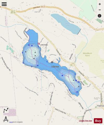
Lake Buel Fishing Map Stats | |
| Title | Lake Buel |
| Scale | 1:6000 |
| Counties | Berkshire |
| Nearby Cities | New Marlborough, Monterey, Great Barrington, Sheffield, Tyringham, Stockbridge, Housatonic, Lee, Sandisfield, Alford |
| Area * | 212.78 acres |
| Shoreline * | 4.17 miles |
| Min Longitude | -73.29 |
| Min Latitude | 42.16 |
| Max Longitude | -73.27 |
| Max Latitude | 42.18 |
| Edition Label 1 | |
| Edition Label 2 | |
| Edition Label 3 | |
| Id | US_MA_malac_lake_buel |
| Country | US |
| Projection | Mercator |
| * some Stats may include nearby/connecting waterbodies | |
|