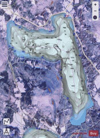
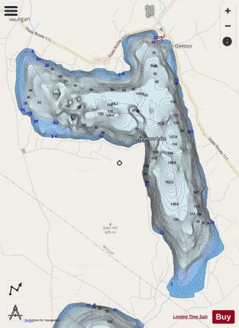
Seymour Lake fishing map is available as part of iBoating : USA Marine & Fishing App(now supported on multiple platforms including Android, iPhone/iPad, MacBook, and Windows(tablet and phone)/PC based chartplotter.).
With our Lake Maps App, you get all the great marine chart app features like fishing spots, along with Seymour Lake depth map. The fishing maps app include HD lake depth contours, along with advanced features found in Fish Finder / Gps Chart Plotter systems, turning your device into a Depth Finder. The Seymour Lake Navigation App provides advanced features of a Marine Chartplotter including adjusting water level offset and custom depth shading. Fishing spots and depth contours layers are available in most Lake maps. Lake navigation features include advanced instrumentation to gather wind speed direction, water temperature, water depth, and accurate GPS with AIS receivers(using NMEA over TCP/UDP). Autopilot support can be enabled during ‘Goto WayPoint’ and ‘Route Assistance’.
Now i-Boating supports Fishing Points in Seymour Lake.
Have more questions about the Nautical Chart App? Ask us.
Fishing Info for Seymour Lake
Seymour Lake is located in the town of Morgan in Orleans County, Vermont, an area known as the Northeast Kingdom. The lake was named for Israel Seymour, one of the original grantees. Natives called it Namagonic ("salmon trout spearing place"). It is one of only two deep, cold, and oligotrophic lakes in the Clyde River system. The freshwater lake covers 1,732 acres (7.01 km2) and is 3 miles (4.8 km) long and 2 miles (3.2 km) wide; its maximum depth is 167 feet (51 m). It is shaped like a giant number "7". The lake is fed by two primary streams, an outlet from Mud Pond and Sucker Brook. The lake drains into Echo Pond, which empties into the Clyde River, Lake Memphremagog and, eventually, Canada's St. Lawrence River. A dam is used for hydroelectric power. Construction on the dam was completed in 1928. It has a normal surface area of 2.8 square miles (7.3 km2). It is owned by Citizens Utilities Company. The dam is made of stone with a concrete core. The foundation is soil. The height is 7 feet (2.1 m) with a length of 68 feet (21 m). Maximum discharge is 85 cubic feet (2.4 m3) per second. Its capacity is 5,200 acre-feet (6,400,000 m3). Normal storage is 3,500 acre-feet (4,300,000 m3). It drains an area of 20.1875 square miles (52.285 km2). The dam was rebuilt in 2004.
More on Wikipedia...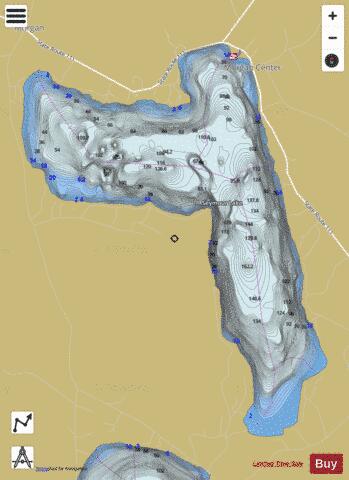
Seymour Lake Fishing Map Stats | |
| Title | Seymour Lake |
| Scale | 1:3000 |
| Counties | Orleans |
| Nearby Cities | Morgan, Holland, Island Pond, Westmore, Derby Center, Derby Line, Newport, Norton, Barton, East Haven |
| Area * | 1777.24 acres |
| Shoreline * | 10.72 miles |
| Min Longitude | -72.02 |
| Min Latitude | 44.87 |
| Max Longitude | -71.97 |
| Max Latitude | 44.91 |
| Edition Label 1 | |
| Edition Label 2 | |
| Edition Label 3 | |
| Id | US_LM_us_vt_ol_mo_seymour |
| Country | US |
| Projection | Mercator |
| * some Stats may include nearby/connecting waterbodies | |
|