Lake Glenn Shoals fishing map is available as part of iBoating : USA Marine & Fishing App(now supported on multiple platforms including Android, iPhone/iPad, MacBook, and Windows(tablet and phone)/PC based chartplotter.).
With our Lake Maps App, you get all the great marine chart app features like fishing spots, along with Lake Glenn Shoals depth map. The fishing maps app include HD lake depth contours, along with advanced features found in Fish Finder / Gps Chart Plotter systems, turning your device into a Depth Finder. The Lake Glenn Shoals Navigation App provides advanced features of a Marine Chartplotter including adjusting water level offset and custom depth shading. Fishing spots and depth contours layers are available in most Lake maps. Lake navigation features include advanced instrumentation to gather wind speed direction, water temperature, water depth, and accurate GPS with AIS receivers(using NMEA over TCP/UDP). Autopilot support can be enabled during ‘Goto WayPoint’ and ‘Route Assistance’.
Now i-Boating supports Fishing Points in Lake Glenn Shoals.
Have more questions about the Nautical Chart App? Ask us.
Fishing Info for Lake Glenn Shoals
Lake Glenn Shoals is a 1,250-acre (5.0 km²) reservoir located in Montgomery County, Illinois. Created in 1976 by damming the Middle Fork of Illinois's Shoal Creek, it was built for recreation, sport fishing, and water supply purposes. The lake is 4 miles (6.5 km) long and 0.4 miles (0.6 km) wide. The nearest town is Hillsboro, Illinois, south of Springfield, Illinois and northeast of Saint Louis, Missouri. Lake Glenn Shoals is managed for bass, bluegill, catfish, crappie, and tiger muskie. The lake is managed in two halves, north and south of the Irving Township bridge, with boats able to go as fast as 35 mph (55 km/h) south of the bridge but only 5 mph (8 km/h) north of the structure. The nearest interstate highway exit is Exit 52 on Interstate 55, near Litchfield. The Illinois Environmental Protection Agency classified Lake Glenn Shoals in April 2006 as an "impaired" lake, due largely to the large quantities of phosphorus, suspended silt, and algae in the lake. These findings could be connected to the significant use of the lake's drainage catchment area by commercial farmers. The municipality of Hillsboro operates the lake and keeps it stocked with fish. A city permit is required for boaters seeking to use the lake.
More on Wikipedia...Popular fish species in this lake include Crappie.
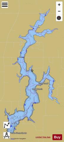
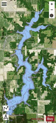
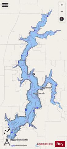
Lake Glenn Shoals Fishing Map Stats | |
| Title | Lake Glenn Shoals |
| Scale | 1:12000 |
| Counties | Montgomery |
| Nearby Cities | Schram City, Hillsboro, Irving, Butler, Taylor Springs, Witt, Coffeen, Raymond, Harvel, Coalton |
| Area * | 1102.37 acres |
| Shoreline * | 25.49 miles |
| Min Longitude | -89.48 |
| Min Latitude | 39.19 |
| Max Longitude | -89.45 |
| Max Latitude | 39.25 |
| Edition Label 1 | |
| Edition Label 2 | |
| Edition Label 3 | |
| Id | US_IL_ildnr_lake_glenn_shoals |
| Country | US |
| Projection | Mercator |
| * some Stats may include nearby/connecting waterbodies | |
|