Little Wall Lake fishing map is available as part of iBoating : USA Marine & Fishing App(now supported on multiple platforms including Android, iPhone/iPad, MacBook, and Windows(tablet and phone)/PC based chartplotter.).
With our Lake Maps App, you get all the great marine chart app features like fishing spots, along with Little Wall Lake depth map. The fishing maps app include HD lake depth contours, along with advanced features found in Fish Finder / Gps Chart Plotter systems, turning your device into a Depth Finder. The Little Wall Lake Navigation App provides advanced features of a Marine Chartplotter including adjusting water level offset and custom depth shading. Fishing spots and depth contours layers are available in most Lake maps. Lake navigation features include advanced instrumentation to gather wind speed direction, water temperature, water depth, and accurate GPS with AIS receivers(using NMEA over TCP/UDP). Autopilot support can be enabled during ‘Goto WayPoint’ and ‘Route Assistance’.
Now i-Boating supports Fishing Points in Little Wall Lake.
Have more questions about the Nautical Chart App? Ask us.
Fishing Info for Little Wall Lake
Little Wall Lake is a 249 acres (101 ha) natural lake in Hamilton County, Iowa, 2 mi (3.2 km) south of the town of Jewell. Said to be glacial in origin, in modern times it has required dredging to keep it from becoming marshland. On the northern end of the lake is Little Wall Lake Park, run by the county, which has camping facilities with full utility hook-ups, three cabins for rent, sixteen tent-only sites, a shower building, a boat ramp, a jetty, and kayak and canoe rentals. lies some 23 mi (37 km) to the north and is not hydrologically connected to Little Wall Lake. On March 28, 2021, two members of the Iowa State University Crew Club drowned in the lake when their racing shell capsized.
More on Wikipedia...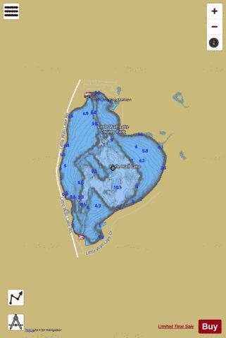
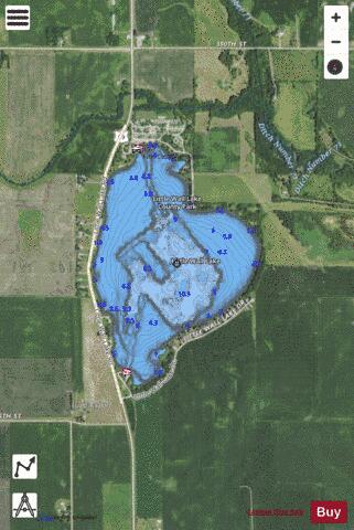
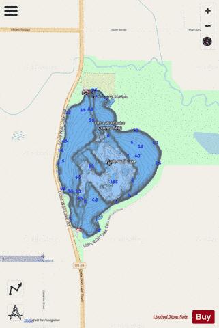
Little Wall Lake Fishing Map Stats | |
| Title | Little Wall Lake |
| Scale | 1:6000 |
| Counties | Hamilton |
| Nearby Cities | Jewell Junction, Randall, Ellsworth, Story City, Kamrar, Stanhope, Gilbert, Roland, Radcliffe, Blairsburg |
| Area * | 245.19 acres |
| Shoreline * | 2.88 miles |
| Min Longitude | -93.64 |
| Min Latitude | 42.26 |
| Max Longitude | -93.63 |
| Max Latitude | 42.28 |
| Edition Label 1 | |
| Edition Label 2 | |
| Edition Label 3 | |
| Id | US_IA_00458522 |
| Country | US |
| Projection | Mercator |
| * some Stats may include nearby/connecting waterbodies | |
|