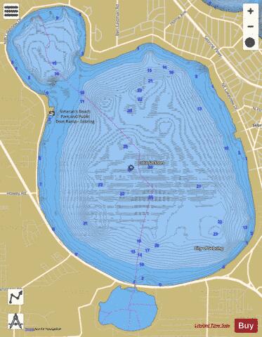
Jackson fishing map is available as part of iBoating : USA Marine & Fishing App(now supported on multiple platforms including Android, iPhone/iPad, MacBook, and Windows(tablet and phone)/PC based chartplotter.).
With our Lake Maps App, you get all the great marine chart app features like fishing spots, along with Jackson lake depth map. The fishing maps app include HD lake depth contours, along with advanced features found in Fish Finder / Gps Chart Plotter systems, turning your device into a Depth Finder. The Jackson Navigation App provides advanced features of a Marine Chartplotter including adjusting water level offset and custom depth shading. Fishing spots and depth contours layers are available in most Lake maps. Lake navigation features include advanced instrumentation to gather wind speed direction, water temperature, water depth, and accurate GPS with AIS receivers(using NMEA over TCP/UDP). Autopilot support can be enabled during ‘Goto WayPoint’ and ‘Route Assistance’.
Now i-Boating supports Fishing Points in Jackson.
Have more questions about the Nautical Chart App? Ask us.
Fishing Info for Jackson
Lake Jackson, covering 3,212 acres (12.95 km2), is located within the city of Sebring, Florida. Sebring is the county seat of Highlands County. Lake Jackson, a healthy freshwater lake, is approximately 25 feet (8 m) at its deepest. Most of the area is fairly shallow. The water is clear as compared to most lakes and the shores are sandy. The lake has various boat ramps, including the popular public ramp at Veterans Beach on the lake's west side. Most ramps are private and there are many private beaches. Three public swimming beaches exist. One at Veterans Beach, at the north end of Lake Jackson, and Hidden Beach, near Faith Lutheran Church, and City Pier Beach is located just to the west of downtown Sebring. City Pier Beach was closed for five years but reopened in 2013. It remains an active public beach.Crescent Beach is a small community beach located at the end of Crescent Drive just off of S.E. Lakeview Dr. A public fishing dock is to the north side of the swimming beach near the downtown. The shore is largely surrounded by homes. A large condominium, The Fountainhead, is on the east side. The only areas not surrounded by residential property are the southwest side, which is bordered by U.S. Highway 27, and an area on the north cove containing a large orange grove. The lake is almost round, with the exception of the north cove, a smaller rounded area. Lake Jackson is connected to Little Lake Jackson by a short canal. Due to the death of novelist Rex Beach in his lakefront home, the lake was renamed Rex Beach Lake in his honor, but the name did not last.
More on Wikipedia...Jackson Fishing Map Stats | |
| Title | Jackson |
| Scale | 1:12000 |
| 1 ft Depth Contours for Anglers | Yes |
| Counties | Highlands |
| Nearby Cities | Sebring, De Soto City, Avon Park, Lorida, Lake Placid, Lemon Grove, Bereah, Placid Lakes, Frostproof, West Frostproof |
| Area * | 3360.92 acres |
| Shoreline * | 11.66 miles |
| Min Longitude | -81.48 |
| Min Latitude | 27.46 |
| Max Longitude | -81.44 |
| Max Latitude | 27.51 |
| Edition Label 1 | |
| Edition Label 2 | |
| Edition Label 3 | |
| Id | US_FL_flsonar_jackson |
| Country | US |
| Projection | Mercator |
| * some Stats may include nearby/connecting waterbodies | |
|


