LAKE WEOHYAKAPKA fishing map is available as part of iBoating : USA Marine & Fishing App(now supported on multiple platforms including Android, iPhone/iPad, MacBook, and Windows(tablet and phone)/PC based chartplotter.).
With our Lake Maps App, you get all the great marine chart app features like fishing spots, along with LAKE WEOHYAKAPKA depth map. The fishing maps app include HD lake depth contours, along with advanced features found in Fish Finder / Gps Chart Plotter systems, turning your device into a Depth Finder. The LAKE WEOHYAKAPKA Navigation App provides advanced features of a Marine Chartplotter including adjusting water level offset and custom depth shading. Fishing spots and depth contours layers are available in most Lake maps. Lake navigation features include advanced instrumentation to gather wind speed direction, water temperature, water depth, and accurate GPS with AIS receivers(using NMEA over TCP/UDP). Autopilot support can be enabled during ‘Goto WayPoint’ and ‘Route Assistance’.
Have more questions about the Nautical Chart App? Ask us.
Fishing Info for LAKE WEOHYAKAPKA
Lake Weohyakapka is a lake in Polk County, Florida, in the United States. The name is derived from the Creek language, most likely meaning "walking on water". The turpentine settlement of Walinwa (Walk In Water) was once located by the lake and was connected to other logging, sawmill, and turpentine industry towns by the Kissimmee River Railway, a Seaboard Air Line Railway subsidiary operated by the then nationalized railroad operator (United States Railroad Administration). Walk-in-the-Water Wildlife Management Area (WMA) abuts one part of the shore.
More on Wikipedia...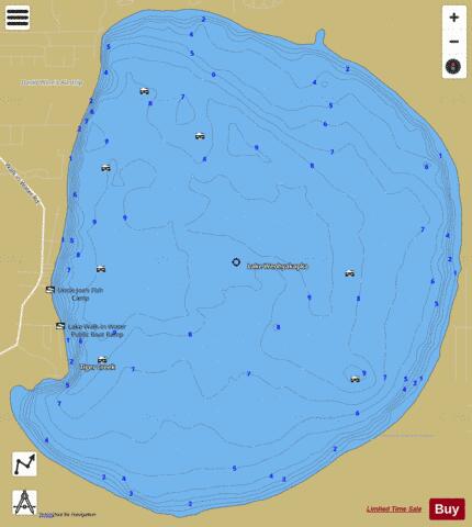
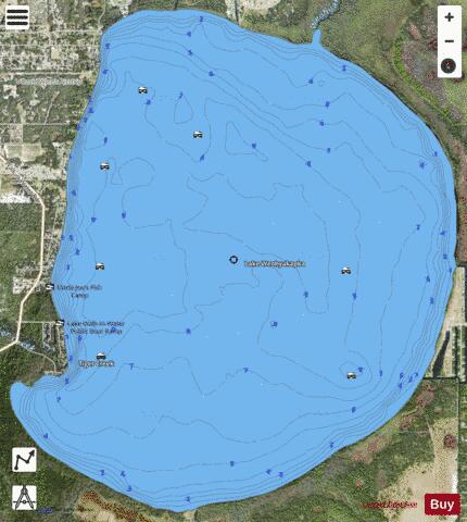
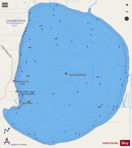
LAKE WEOHYAKAPKA Fishing Map Stats | |
| Title | LAKE WEOHYAKAPKA |
| Scale | 1:12000 |
| 1 ft Depth Contours for Anglers | Yes |
| Counties | Polk |
| Nearby Cities | Alcoma, Babson Park, Hillcrest Heights, Frostproof, Highland Park, West Frostproof, Lake Wales, Avon Park, West Lake Wales, Waverly |
| Area * | 7567.43 acres |
| Shoreline * | 13.59 miles |
| Min Longitude | -81.45 |
| Min Latitude | 27.79 |
| Max Longitude | -81.38 |
| Max Latitude | 27.85 |
| Edition Label 1 | |
| Edition Label 2 | |
| Edition Label 3 | |
| Id | US_FL_00294192 |
| Country | US |
| Projection | Mercator |
| * some Stats may include nearby/connecting waterbodies | |
|