LAKE ALTAMAHA fishing map is available as part of iBoating : USA Marine & Fishing App(now supported on multiple platforms including Android, iPhone/iPad, MacBook, and Windows(tablet and phone)/PC based chartplotter.).
With our Lake Maps App, you get all the great marine chart app features like fishing spots, along with LAKE ALTAMAHA depth map. The fishing maps app include HD lake depth contours, along with advanced features found in Fish Finder / Gps Chart Plotter systems, turning your device into a Depth Finder. The LAKE ALTAMAHA Navigation App provides advanced features of a Marine Chartplotter including adjusting water level offset and custom depth shading. Fishing spots and depth contours layers are available in most Lake maps. Lake navigation features include advanced instrumentation to gather wind speed direction, water temperature, water depth, and accurate GPS with AIS receivers(using NMEA over TCP/UDP). Autopilot support can be enabled during ‘Goto WayPoint’ and ‘Route Assistance’.
Now i-Boating supports Fishing Points in LAKE ALTAMAHA.
Have more questions about the Nautical Chart App? Ask us.
Fishing Info for LAKE ALTAMAHA
Lake Altamaha is on the south side of Lake Wales, Florida, just east of Highway US 27. To the east is Miami Street and citrus groves. To the south is a motel and to the north is another motel and an abandoned restaurant. Across US 27 is Lake Wales Cemetery. There is no public swimming beach or boat ramp on this lake's shore. However, the public can gain access both along Miami Street and US 27. The Hook and Bullet website says Lake Altamaha contains blue catfish, bullhead and gar.
More on Wikipedia...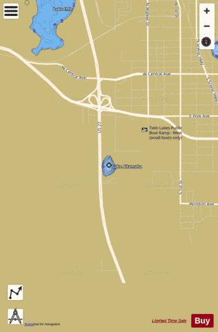
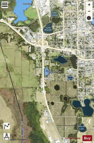
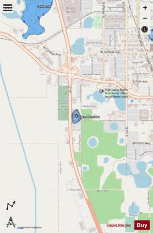
LAKE ALTAMAHA Fishing Map Stats | |
| Title | LAKE ALTAMAHA |
| Scale | 1:3000 |
| 1 ft Depth Contours for Anglers | Yes |
| Counties | Polk |
| Nearby Cities | Lake Wales, Highland Park, West Lake Wales, Waverly, Babson Park, Hillcrest Heights, Alcoma, Alturas, Dundee, Wahneta |
| Area * | 7.62 acres |
| Shoreline * | 0.41 miles |
| Min Longitude | -81.60 |
| Min Latitude | 27.89 |
| Max Longitude | -81.60 |
| Max Latitude | 27.89 |
| Edition Label 1 | |
| Edition Label 2 | |
| Edition Label 3 | |
| Id | US_FL_00277820 |
| Country | US |
| Projection | Mercator |
| * some Stats may include nearby/connecting waterbodies | |
|