Placid fishing map is available as part of iBoating : USA Marine & Fishing App(now supported on multiple platforms including Android, iPhone/iPad, MacBook, and Windows(tablet and phone)/PC based chartplotter.).
With our Lake Maps App, you get all the great marine chart app features like fishing spots, along with Placid lake depth map. The fishing maps app include HD lake depth contours, along with advanced features found in Fish Finder / Gps Chart Plotter systems, turning your device into a Depth Finder. The Placid Navigation App provides advanced features of a Marine Chartplotter including adjusting water level offset and custom depth shading. Fishing spots and depth contours layers are available in most Lake maps. Lake navigation features include advanced instrumentation to gather wind speed direction, water temperature, water depth, and accurate GPS with AIS receivers(using NMEA over TCP/UDP). Autopilot support can be enabled during ‘Goto WayPoint’ and ‘Route Assistance’.
Now i-Boating supports Fishing Points in Placid.
Have more questions about the Nautical Chart App? Ask us.
Fishing Info for Placid
Lake Placid, a gourd-shaped lake, has a surface area of 3,406.03 acres (13,783,700 m2). This lake is south of the city of Lake Placid, Florida; it is just outside the south city limits of the city. This lake was once known as Lake Childs. The area immediately surrounding it is mostly rural, but there are housing developments abutting the lake on part of its west side. Placid View Drive runs along part of the west side and Old State Route 8 runs along part of the east side. Lake Placid provides public access along part of its shore. There are two public boat ramps on shore, one at 150 Harris Drive (on the northeast side) and the other at 3349 Placid View Drive (on the west side of the lake). There are no public swimming areas along the lake shore, but it can be fished from the shore. This lake has a variety of game fish: largemouth bass, catfish, bream, bluegill, redear sunfish, blue catfish, crappie. This lake named Lake Placid is one of several Lake Placids in Florida, as well as other places.
More on Wikipedia...Popular fish species in this lake include Crappie, Largemouth bass and Redear sunfish.
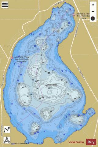
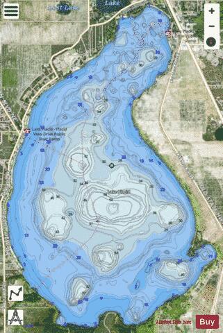
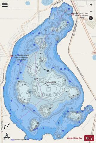
Placid Fishing Map Stats | |
| Title | Placid |
| Scale | 1:24000 |
| 1 ft Depth Contours for Anglers | Yes |
| Counties | Highlands |
| Nearby Cities | Lake Placid, Placid Lakes, Venus, De Soto City, Lorida, Plains, Sebring, Brighton, Cornwell, Palmdale |
| Area * | 3344.20 acres |
| Shoreline * | 11.63 miles |
| Min Longitude | -81.38 |
| Min Latitude | 27.22 |
| Max Longitude | -81.34 |
| Max Latitude | 27.27 |
| Edition Label 1 | |
| Edition Label 2 | |
| Edition Label 3 | |
| Id | US_FA_FL_highlands12055plac |
| Country | US |
| Projection | Mercator |
| * some Stats may include nearby/connecting waterbodies | |
|