Letta fishing map is available as part of iBoating : USA Marine & Fishing App(now supported on multiple platforms including Android, iPhone/iPad, MacBook, and Windows(tablet and phone)/PC based chartplotter.).
With our Lake Maps App, you get all the great marine chart app features like fishing spots, along with Letta lake depth map. The fishing maps app include HD lake depth contours, along with advanced features found in Fish Finder / Gps Chart Plotter systems, turning your device into a Depth Finder. The Letta Navigation App provides advanced features of a Marine Chartplotter including adjusting water level offset and custom depth shading. Fishing spots and depth contours layers are available in most Lake maps. Lake navigation features include advanced instrumentation to gather wind speed direction, water temperature, water depth, and accurate GPS with AIS receivers(using NMEA over TCP/UDP). Autopilot support can be enabled during ‘Goto WayPoint’ and ‘Route Assistance’.
Now i-Boating supports Fishing Points in Letta.
Have more questions about the Nautical Chart App? Ask us.
Fishing Info for Letta
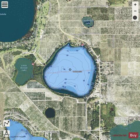
Lake Letta is a natural freshwater lake in Highlands County, Florida. It has a 478-acre (1,930,000 m2) surface area. It is bounded on the east and north by Florida State Highway 17, on the southeast by Lake Letta Drive, on the south by citrus orchards, on the west by Little Bonnet Lake and a golf course and on the northwest by pastures. It is connected to Little Lake Bonnet by a canal. Lake Letta is about 0.6 miles (0.97 km) southwest of the city limits of Avon Park, Florida. Residences, along Highway 17 and Lake Letta Drive, line most of the east and southeast sides of Lake Letta. Lake Letta RV Park is across Highway 17 from the lake in the middle of its east side. Lake Letta has a public boat ramp on its north side, just off Highway 17. Fishing is allowed; one posting on the Hook and Bullet website says the lake has sturgeon, warmouth and blue catfish. However, this lake has no public swimming areas.
More on Wikipedia...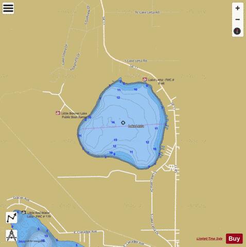
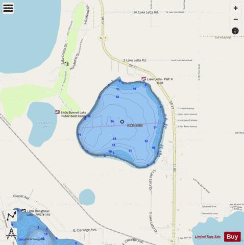
Letta Fishing Map Stats | |
| Title | Letta |
| Scale | 1:12000 |
| 1 ft Depth Contours for Anglers | Yes |
| Counties | Highlands |
| Nearby Cities | Avon Park, Sebring, De Soto City, Bereah, Frostproof, West Frostproof, Lemon Grove, Lorida, Hillcrest Heights, Babson Park |
| Area * | 396.75 acres |
| Shoreline * | 3.70 miles |
| Min Longitude | -81.47 |
| Min Latitude | 27.55 |
| Max Longitude | -81.45 |
| Max Latitude | 27.57 |
| Edition Label 1 | |
| Edition Label 2 | |
| Edition Label 3 | |
| Id | US_FA_FL_highlands12055_letta |
| Country | US |
| Projection | Mercator |
| * some Stats may include nearby/connecting waterbodies | |
|