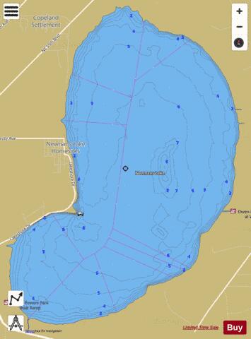
Newnans fishing map is available as part of iBoating : USA Marine & Fishing App(now supported on multiple platforms including Android, iPhone/iPad, MacBook, and Windows(tablet and phone)/PC based chartplotter.).
With our Lake Maps App, you get all the great marine chart app features like fishing spots, along with Newnans lake depth map. The fishing maps app include HD lake depth contours, along with advanced features found in Fish Finder / Gps Chart Plotter systems, turning your device into a Depth Finder. The Newnans Navigation App provides advanced features of a Marine Chartplotter including adjusting water level offset and custom depth shading. Fishing spots and depth contours layers are available in most Lake maps. Lake navigation features include advanced instrumentation to gather wind speed direction, water temperature, water depth, and accurate GPS with AIS receivers(using NMEA over TCP/UDP). Autopilot support can be enabled during ‘Goto WayPoint’ and ‘Route Assistance’.
Now i-Boating supports Fishing Points in Newnans.
Have more questions about the Nautical Chart App? Ask us.
Fishing Info for Newnans
Newnans Lake (or Newnan's Lake) is a lake located off State Road 20, east of Gainesville, Florida. Approximately 1.12 miles (2 km) wide, Newnans Lake is home to many forms of wildlife, and had been designated as a protected site by Alachua County. The lake was originally known as Lake Pithlachocco. It was renamed after Daniel Newnan, who led a detachment of Georgia militia that fought an inconclusive battle with Seminoles near the lake in 1812. Newnans Lake is located 8 kilometres (5.0 mi) east of Gainesville. It averages 1.5 metres (4.9 ft) deep, and has a maximum depth of 3.6 metres (12 ft). It has an area of approximately 3,000 hectares (7,400 acres). Surface flow into the lake is primarily from the north, via Hatchett Creek, Little Hatchett Creek, and other streams. The lake's drainage basin has an area of 308 square kilometres (119 sq mi). The primary outlet is Prairie Creek on the south side of the lake. A spillway as installed in 1967 to control the water level of the lake. It is classified as eutrophic. Before the spillway was installed, the water level of the lake fluctuated seasonally. The margins of the lake are dominated by Cypress swamp forests. Forty-four archaeological sites have been identified on the shores of the lake, or at nearby ponds and marshes. The lake has been designated a Fish Management Area by the Florida Fish and Wildlife Conservation Commission and the Alachua County Board of County Commissioners. Prairie Creek, the principal outlet of Newnans Lake, originally drained into Paynes Prairie. The Camp family, which owned Paynes Prairie and operated a cattle ranch on it, wanted to drain the prairie to improve it as pasture. After very heavy rain flooded the Prairie in 1927, the Camps commenced projects to lower the water table on the Prairie that included diverting Prairie Creek to the River Styx, which flows into Orange Lake. In the Spring and Summer of 2000, a drought revealed canoe remnants. Fifty-five of the canoes were analyzed through radiocarbon assays, which showed 41 of them to date to between 2300 and 5000 B.C. The wood choice and manufacturing techniques were comparable to other Archaic Period canoes. The discovery led to the site's addition to the National Register of Historic Places in March 2001. The 1,005-acre (407 ha) Newnans Lake State Forest is located to the west of the lake. The Newnans Lake Conservation Area owned by the St. Johns River Water Management District is primarily along the north end of the lake.
More on Wikipedia...Newnans Fishing Map Stats | |
| Title | Newnans |
| Scale | 1:24000 |
| 1 ft Depth Contours for Anglers | Yes |
| Counties | Alachua |
| Nearby Cities | Rochelle, Fairbanks, Gainesville, Campville, Orange Heights, Micanopy, Hawthorne, Waldo, Arredondo, Lochloosa |
| Area * | 5979.99 acres |
| Shoreline * | 15.18 miles |
| Min Longitude | -82.25 |
| Min Latitude | 29.61 |
| Max Longitude | -82.20 |
| Max Latitude | 29.68 |
| Edition Label 1 | |
| Edition Label 2 | |
| Edition Label 3 | |
| Id | US_FA_FL_alachua12001_newn |
| Country | US |
| Projection | Mercator |
| * some Stats may include nearby/connecting waterbodies | |
|


