Knapp Lake fishing map is available as part of iBoating : USA Marine & Fishing App(now supported on multiple platforms including Android, iPhone/iPad, MacBook, and Windows(tablet and phone)/PC based chartplotter.).
With our Lake Maps App, you get all the great marine chart app features like fishing spots, along with Knapp Lake depth map. The fishing maps app include HD lake depth contours, along with advanced features found in Fish Finder / Gps Chart Plotter systems, turning your device into a Depth Finder. The Knapp Lake Navigation App provides advanced features of a Marine Chartplotter including adjusting water level offset and custom depth shading. Fishing spots and depth contours layers are available in most Lake maps. Lake navigation features include advanced instrumentation to gather wind speed direction, water temperature, water depth, and accurate GPS with AIS receivers(using NMEA over TCP/UDP). Autopilot support can be enabled during ‘Goto WayPoint’ and ‘Route Assistance’.
Now i-Boating supports Fishing Points in Knapp Lake.
Have more questions about the Nautical Chart App? Ask us.
Fishing Info for Knapp Lake
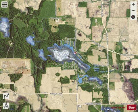
Knapp Lake is a small natural lake located in western Noble County, Indiana. Knapp Lake is directly attached to Little Bause Lake via a channel and Little Knapp Lake on the south and southwest and Moss Lake to the north. Little Bause has development around its shores while Little Knapp is undeveloped. and Gilbert Lake, both undeveloped for the most part form the southern part of the as it flows northward to Lake Wawasee through Moss Lake. The southwest, northeast and north shores comprise the bulk of the homes on the lake. The north shore has five man-made channels. The northwest shore is forested. Farmland surrounds mostly the east and south beyond inhabited areas. In 1999, with the assistance of the Indiana Department of Natural Resources, the Wawasee Property Owners Association purchased 13.52 acres (5.47 ha) of land and wetlands on Knapp Lake and 19.65 acres (7.95 ha) surrounding Little Knapp Lake.
More on Wikipedia...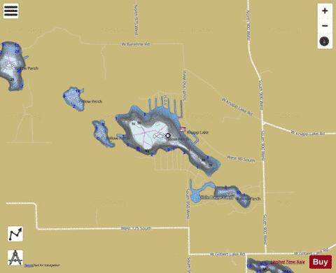
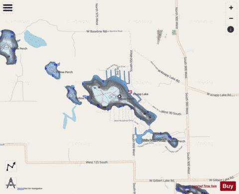
Knapp Lake Fishing Map Stats | |
| Title | Knapp Lake |
| Scale | 1:1500 |
| Counties | Noble |
| Nearby Cities | Cromwell, Kimmell, North Webster, Wolflake, Ligonier, Larwill, Syracuse, Pierceton, Merriam, Tri-Lakes |
| Area * | 88.74 acres |
| Shoreline * | 3.42 miles |
| Min Longitude | -85.61 |
| Min Latitude | 41.34 |
| Max Longitude | -85.60 |
| Max Latitude | 41.35 |
| Edition Label 1 | |
| Edition Label 2 | |
| Edition Label 3 | |
| Id | US_DL_IN_00452454 |
| Country | US |
| Projection | Mercator |
| * some Stats may include nearby/connecting waterbodies | |
|