Whiskeytown Lake fishing map is available as part of iBoating : USA Marine & Fishing App(now supported on multiple platforms including Android, iPhone/iPad, MacBook, and Windows(tablet and phone)/PC based chartplotter.).
With our Lake Maps App, you get all the great marine chart app features like fishing spots, along with Whiskeytown Lake depth map. The fishing maps app include HD lake depth contours, along with advanced features found in Fish Finder / Gps Chart Plotter systems, turning your device into a Depth Finder. The Whiskeytown Lake Navigation App provides advanced features of a Marine Chartplotter including adjusting water level offset and custom depth shading. Fishing spots and depth contours layers are available in most Lake maps. Lake navigation features include advanced instrumentation to gather wind speed direction, water temperature, water depth, and accurate GPS with AIS receivers(using NMEA over TCP/UDP). Autopilot support can be enabled during ‘Goto WayPoint’ and ‘Route Assistance’.
Now i-Boating supports Fishing Points in Whiskeytown Lake.
Have more questions about the Nautical Chart App? Ask us.
Fishing Info for Whiskeytown Lake
Whiskeytown Lake is a reservoir in Shasta County in northwestern California, United States, about 8 miles (13 km) west of Redding. The lake is in the Whiskeytown Unit of the Whiskeytown-Shasta-Trinity National Recreation Area. Whiskeytown Lake has a capacity of 241,100 acre⋅ft (297.4 Gl) and is formed by Whiskeytown Dam on Clear Creek. Additional water comes from Lewiston Reservoir, supplied by the Trinity River, via the Clear Creek Tunnel, which comes from the bottom of Lewiston Lake. The California Office of Environmental Health Hazard Assessment has issued a safe eating advisory for any fish caught in the Whiskeytown Lake due to elevated levels of mercury.
More on Wikipedia...Popular fish species in this lake include Largemouth bass, Rainbow trout, Smallmouth bass and Spotted bass.
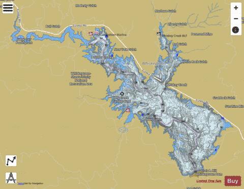
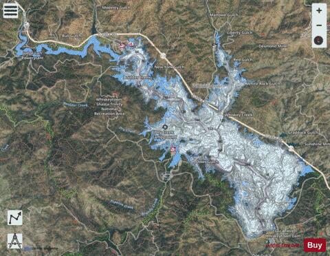
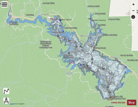
Whiskeytown Lake Fishing Map Stats | |
| Title | Whiskeytown Lake |
| Sailing Clubs in this Chart region | |
| Whiskeytown Sailing Club | |
| Scale | 1:12000 |
| Counties | Shasta |
| Nearby Cities | Shasta, French Gulch, Keswick, Igo, Redding, Ono, Shasta Lake, Lewiston, Mountain Gate, Anderson |
| Area * | 3114.51 acres |
| Shoreline * | 44.75 miles |
| Min Longitude | -122.63 |
| Min Latitude | 40.60 |
| Max Longitude | -122.52 |
| Max Latitude | 40.66 |
| Edition Label 1 | |
| Edition Label 2 | |
| Edition Label 3 | |
| Id | US_DL_CA_00268967 |
| Country | US |
| Projection | Mercator |
| * some Stats may include nearby/connecting waterbodies | |
|