Loch Lomond fishing map is available as part of iBoating : USA Marine & Fishing App(now supported on multiple platforms including Android, iPhone/iPad, MacBook, and Windows(tablet and phone)/PC based chartplotter.).
With our Lake Maps App, you get all the great marine chart app features like fishing spots, along with Loch Lomond lake depth map. The fishing maps app include HD lake depth contours, along with advanced features found in Fish Finder / Gps Chart Plotter systems, turning your device into a Depth Finder. The Loch Lomond Navigation App provides advanced features of a Marine Chartplotter including adjusting water level offset and custom depth shading. Fishing spots and depth contours layers are available in most Lake maps. Lake navigation features include advanced instrumentation to gather wind speed direction, water temperature, water depth, and accurate GPS with AIS receivers(using NMEA over TCP/UDP). Autopilot support can be enabled during ‘Goto WayPoint’ and ‘Route Assistance’.
Now i-Boating supports Fishing Points in Loch Lomond.
Have more questions about the Nautical Chart App? Ask us.
Fishing Info for Loch Lomond
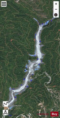
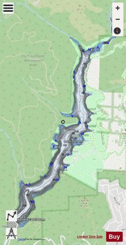
Loch Lomond is a reservoir in the Santa Cruz Mountains near Lompico in Santa Cruz County, California. Part of the Santa Cruz Water Department system, it was created by building the Newell Creek Dam across Newell Creek – a tributary of the San Lorenzo River. The dam is an earth-fill barricade, measuring 190 ft (58 m) by 750 ft (230 m). It was financed by bond issuance, and completed in the Fall of 1960; impounded water first ran over the spillway in March 1963. The reservoir is 175 acres (71 ha). It is 2.5 mi (4.0 km) long, 0.25 mi (0.40 km) wide, approximately 150 ft (46 m) deep, with a 9,200 acre⋅ft (11,300,000 m3) capacity. It provides a main portion of the drinking water supply for the city of Santa Cruz, California and also supplies other nearby county areas. Boating, fishing, picnicking and hiking take place at the reservoir. No daily private boat launching is permitted. No swimming is allowed. The reservoir has a boat rental and snack shop and is open every day from March 1 to September 15, and weekends only from Labor Day to October 17. Surrounding the reservoir is the Loch Lomond Recreation Area, which is owned and operated by the City of Santa Cruz Water Department. It has hiking trails, picnic areas, and boating access.
More on Wikipedia...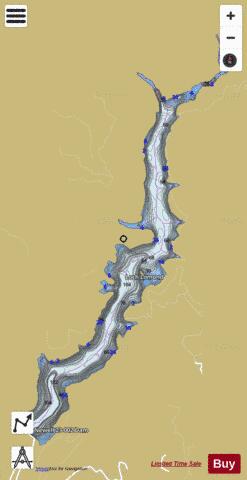
Loch Lomond Fishing Map Stats | |
| Title | Loch Lomond |
| Scale | 1:3000 |
| Counties | Santa Cruz |
| Nearby Cities | Lompico, Ben Lomond, Zayante, Brookdale, Felton, Mount Hermon, Boulder Creek, Scotts Valley, Paradise Park, Bonny Doon |
| Area * | 171.55 acres |
| Shoreline * | 6.88 miles |
| Min Longitude | -122.07 |
| Min Latitude | 37.10 |
| Max Longitude | -122.06 |
| Max Latitude | 37.13 |
| Edition Label 1 | |
| Edition Label 2 | |
| Edition Label 3 | |
| Id | US_DL_CA_00227451 |
| Country | US |
| Projection | Mercator |
| * some Stats may include nearby/connecting waterbodies | |
|