Lake Saltonstall fishing map is available as part of iBoating : USA Marine & Fishing App(now supported on multiple platforms including Android, iPhone/iPad, MacBook, and Windows(tablet and phone)/PC based chartplotter.).
With our Lake Maps App, you get all the great marine chart app features like fishing spots, along with Lake Saltonstall depth map. The fishing maps app include HD lake depth contours, along with advanced features found in Fish Finder / Gps Chart Plotter systems, turning your device into a Depth Finder. The Lake Saltonstall Navigation App provides advanced features of a Marine Chartplotter including adjusting water level offset and custom depth shading. Fishing spots and depth contours layers are available in most Lake maps. Lake navigation features include advanced instrumentation to gather wind speed direction, water temperature, water depth, and accurate GPS with AIS receivers(using NMEA over TCP/UDP). Autopilot support can be enabled during ‘Goto WayPoint’ and ‘Route Assistance’.
Now i-Boating supports Fishing Points in Lake Saltonstall.
Have more questions about the Nautical Chart App? Ask us.
Fishing Info for Lake Saltonstall
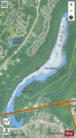
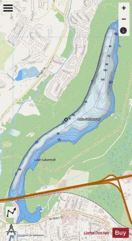
Lake Saltonstall (Lonotonoquet in Quinnipiac), is a long narrow lake located in south-central Connecticut. It covers an area of approximately 0.66 square miles (1.7 km2) and is nestled in the center of the trap rock Saltonstall Mountain. The lake is surrounded by forest and serves as part of the local water supply for surrounding towns. The lake and the area around it is owned by the South Central Connecticut Regional Water Authority, a company which also regulates fishing and rents boats. Private boats are not allowed. A Regional Water Authority (RWA) recreation permit may be purchased, which provides access to hiking trails, fishing and boat rentals at Lake Saltonstall and other properties owned and maintained by the RWA. There are a variety of fish native to Lake Saltonstall in addition to those that are stocked by the RWA. Fish in Lake Saltonstall include largemouth bass, smallmouth bass, black crappie, walleye, trout, yellow perch and carp. Interstate 95 runs across the southern edge of the lake, connecting the towns of East Haven, Connecticut and Branford, Connecticut. Lake Saltonstall's maximum depth does not exceed 113 feet (34 m) and its mean depth is 41 feet (12 m).
More on Wikipedia...Popular fish species in this lake include Black crappie, Largemouth bass, Smallmouth bass, Walleye and Yellow perch.
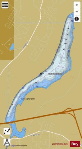
Lake Saltonstall Fishing Map Stats | |
| Title | Lake Saltonstall |
| Scale | 1:12000 |
| Counties | New Haven |
| Nearby Cities | East Haven, Branford, North Branford, New Haven, North Haven, West Haven, Hamden, Woodmont, Wallingford, Guilford |
| Area * | 413.38 acres |
| Shoreline * | 7.68 miles |
| Min Longitude | -72.86 |
| Min Latitude | 41.28 |
| Max Longitude | -72.84 |
| Max Latitude | 41.31 |
| Edition Label 1 | |
| Edition Label 2 | |
| Edition Label 3 | |
| Id | US_CT_ctserv_lake_saltonstall |
| Country | US |
| Projection | Mercator |
| * some Stats may include nearby/connecting waterbodies | |
|