Lake Standley fishing map is available as part of iBoating : USA Marine & Fishing App(now supported on multiple platforms including Android, iPhone/iPad, MacBook, and Windows(tablet and phone)/PC based chartplotter.).
With our Lake Maps App, you get all the great marine chart app features like fishing spots, along with Lake Standley depth map. The fishing maps app include HD lake depth contours, along with advanced features found in Fish Finder / Gps Chart Plotter systems, turning your device into a Depth Finder. The Lake Standley Navigation App provides advanced features of a Marine Chartplotter including adjusting water level offset and custom depth shading. Fishing spots and depth contours layers are available in most Lake maps. Lake navigation features include advanced instrumentation to gather wind speed direction, water temperature, water depth, and accurate GPS with AIS receivers(using NMEA over TCP/UDP). Autopilot support can be enabled during ‘Goto WayPoint’ and ‘Route Assistance’.
Now i-Boating supports Fishing Points in Lake Standley.
Have more questions about the Nautical Chart App? Ask us.
Fishing Info for Lake Standley
Standley Lake is a 1,200-acre (4.9 km2) reservoir located in Westminster, Colorado. While originally constructed to provide water for the agricultural irrigation of the surrounding region northwest of Denver, it now serves primarily as the municipal water supply for the cities of Westminster, Northglenn, and Thornton. The lake is also used for recreation, and is the prominent feature of the surrounding 3,000-acre (12 km2) Standley Lake Regional Park. The reservoir has a maximum capacity of approximately 42,000 acre-feet (52,000,000 m3) and maximum depth of 96 feet. Most of the reservoir's water is transported over 16 miles from Clear Creek to the south by way of the , and . It also receives water from Coal Creek by way of the and from Woman Creek. The lake is owned by the Farmers Reservoir and Irrigation Company (FRICO) while the surrounding park and the recreational use of the lake are managed by the City of Westminster.
More on Wikipedia...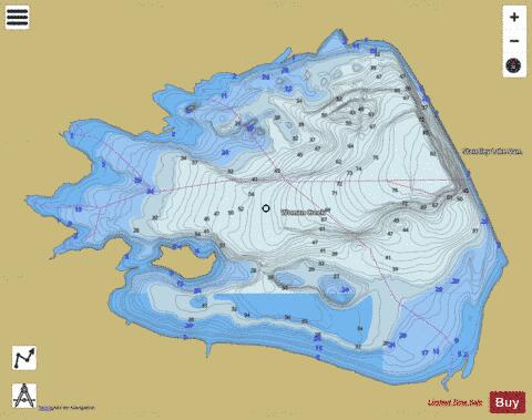

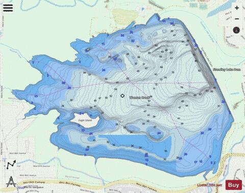
Lake Standley Fishing Map Stats | |
| Title | Lake Standley |
| Scale | 1:6000 |
| Counties | Jefferson |
| Nearby Cities | Leyden, Broomfield, Arvada, Westminster, Superior, Wheat Ridge, Mountain View, Louisville, Edgewater, Western Hills |
| Area * | 1235.51 acres |
| Shoreline * | 9.35 miles |
| Min Longitude | -105.15 |
| Min Latitude | 39.85 |
| Max Longitude | -105.11 |
| Max Latitude | 39.88 |
| Edition Label 1 | |
| Edition Label 2 | |
| Edition Label 3 | |
| Id | US_CO_00202833 |
| Country | US |
| Projection | Mercator |
| * some Stats may include nearby/connecting waterbodies | |
|