Sand Lake fishing map is available as part of iBoating : USA Marine & Fishing App(now supported on multiple platforms including Android, iPhone/iPad, MacBook, and Windows(tablet and phone)/PC based chartplotter.).
With our Lake Maps App, you get all the great marine chart app features like fishing spots, along with Sand Lake depth map. The fishing maps app include HD lake depth contours, along with advanced features found in Fish Finder / Gps Chart Plotter systems, turning your device into a Depth Finder. The Sand Lake Navigation App provides advanced features of a Marine Chartplotter including adjusting water level offset and custom depth shading. Fishing spots and depth contours layers are available in most Lake maps. Lake navigation features include advanced instrumentation to gather wind speed direction, water temperature, water depth, and accurate GPS with AIS receivers(using NMEA over TCP/UDP). Autopilot support can be enabled during ‘Goto WayPoint’ and ‘Route Assistance’.
Now i-Boating supports Fishing Points in Sand Lake.
Have more questions about the Nautical Chart App? Ask us.
Fishing Info for Sand Lake
In Anchorage, Alaska, Sand Lake is the area surrounding Sand Lake, a stocked lake in the southwest part of the city. It is south of the Ted Stevens International Airport and Lake Spenard. The lake itself has a surface area of 78 acres (320,000 m2). It is one of the few big-city lakes in the world with common and Pacific loon populations. Its shores are mostly privately owned, but a small park to the northeast allows public access. Kayakers, fishermen, picnickers and birdwatchers frequent the area. The lake is stocked with fish by the Alaska Department of Fish and Game with rainbow trout and salmon. Northern pike, illegally introduced to the lake, are significant predators on rainbow trout and salmon and have a detrimental impact on these populations. In 2006 residents of the lake asked the Alaska Department of Fish and Game (ADF&G) for help in removing northern pike from the lake and initial planning began resulting in the application of the fish poison rotenone in 2009 to restore the fishery. In 2010 surveys confirmed that the lake was free of northern pike and ADF&G restocked the lake with rainbow trout, Arctic char, and Arctic grayling. In July 2011 an invasive aquatic plant, Elodea, was discovered in dense growths in Sand Lake as well as nearby DeLong and Little Campbell Lakes. It has also been found in Chena Slough and Chena Lakes in Fairbanks; a few lakes near Cordova; and Daniels, Stormy, and Beck Lakes on the Kenai Peninsula. It is suspected that it may have entered the lake through the dumping of an aquarium as this species is a popular aquatic plant used by aquarium hobbyists and is commonly used as a teaching specimen in local middle schools. This introduction is of much concern due to Elodea's ability to negatively impact recreational uses, floatplane operations, fish and wildlife habitat, and property values. Another local attraction is Kincaid Park to the west.Generally, the residential area becomes more affluent near the lake, with a wide range of demographics expanding out. The local High School is Dimond High School although some students attend South Anchorage High School. The neighborhood was hard hit by the 2005 National Scout Jamboree accident, which killed four Anchorage residents. Recent developments in the area include the addition of over 700 homes to in the new West Park subdivision, one of the largest additions to Anchorage in years.
More on Wikipedia...Popular fish species in this lake include Rainbow trout.
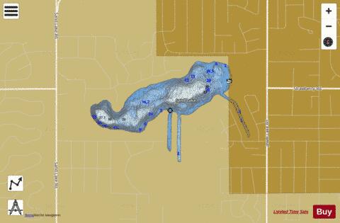
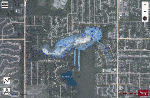
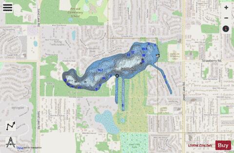
Sand Lake Fishing Map Stats | |
| Title | Sand Lake |
| Scale | 1:3000 |
| Counties | Anchorage |
| Nearby Cities | Spenard, Anchorage, Nunaka Valley, Knik, Hope, Eagle River, Houston, Chugiak, Cottonwood, Willow |
| Area * | 73.22 acres |
| Shoreline * | 3.13 miles |
| Min Longitude | -149.98 |
| Min Latitude | 61.15 |
| Max Longitude | -149.95 |
| Max Latitude | 61.15 |
| Edition Label 1 | |
| Edition Label 2 | |
| Edition Label 3 | |
| Id | US_CC_AK_sand_lake_ju20 |
| Country | US |
| Projection | Mercator |
| * some Stats may include nearby/connecting waterbodies | |
|