Fontenelle Reservoir fishing map is available as part of iBoating : USA Marine & Fishing App(now supported on multiple platforms including Android, iPhone/iPad, MacBook, and Windows(tablet and phone)/PC based chartplotter.).
With our Lake Maps App, you get all the great marine chart app features like fishing spots, along with Fontenelle Reservoir depth map. The fishing maps app include HD lake depth contours, along with advanced features found in Fish Finder / Gps Chart Plotter systems, turning your device into a Depth Finder. The Fontenelle Reservoir Navigation App provides advanced features of a Marine Chartplotter including adjusting water level offset and custom depth shading. Fishing spots and depth contours layers are available in most Lake maps. Lake navigation features include advanced instrumentation to gather wind speed direction, water temperature, water depth, and accurate GPS with AIS receivers(using NMEA over TCP/UDP). Autopilot support can be enabled during ‘Goto WayPoint’ and ‘Route Assistance’.
Now i-Boating supports Fishing Points in Fontenelle Reservoir.
Have more questions about the Nautical Chart App? Ask us.
Fishing Info for Fontenelle Reservoir
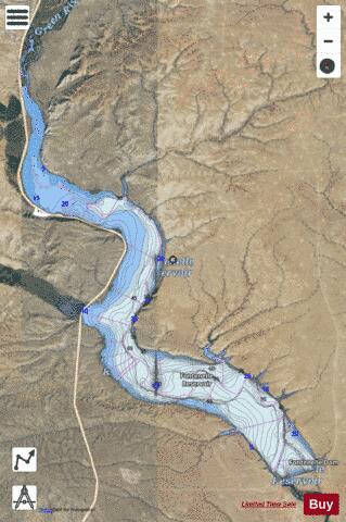
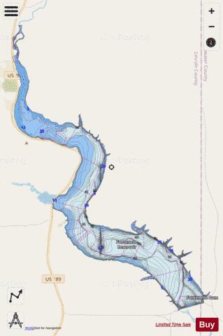
Fontenelle Reservoir is an artificial reservoir located in southwest Wyoming. It lies almost entirely within Lincoln County, although the east end of the Fontenelle Dam and a tiny portion of the reservoir are actually in northwestern Sweetwater County. Impounded by Fontenelle Dam, the reservoir acts primarily as a storage reservoir for the U.S. Bureau of Reclamation's Colorado River Storage Project, retaining Wyoming water in the state as a means of asserting Wyoming's water rights, with a secondary purpose of power generation. Water from Fontenelle Reservoir is used in local industries such as mining and power generation. Although initially projected to provide irrigation water for agriculture, the irrigation component was downgraded after difficulties with efficient irrigation in Wyoming's high semi-desert became apparent. Plagued by chronic leakage problems at the dam, the reservoir was hurriedly emptied in 1965 and 1986 amid concerns about dam failure. The reservoir has facilities for recreation, with boat launching ramps and campgrounds. Fishing is available for brown, cutthroat and rainbow trout. The land used for the Fontenelle Reservoir and dam was previously the Stepp Ranch, owned by one of the few black ranching families in Wyoming in the 1960s. The Stepps fought for their land in court, but ultimately lost. The land had been in the Stepp family since the turn of the 19th century. [4]
More on Wikipedia...Popular fish species in this lake include Rainbow trout.
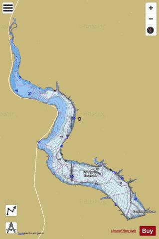
Fontenelle Reservoir Fishing Map Stats | |
| Title | Fontenelle Reservoir |
| Scale | 1:24000 |
| Counties | Lincoln, Sweetwater |
| Nearby Cities | Fontenelle, La Barge, Calpet, Opal, Big Piney, Marbleton, Granger, Verne, Frontier, Kemmerer |
| Area * | 7831.09 acres |
| Shoreline * | 49.68 miles |
| Min Longitude | -110.19 |
| Min Latitude | 42.03 |
| Max Longitude | -110.05 |
| Max Latitude | 42.18 |
| Edition Label 1 | |
| Edition Label 2 | |
| Edition Label 3 | |
| Id | US_AA_WY_01588609 |
| Country | US |
| Projection | Mercator |
| * some Stats may include nearby/connecting waterbodies | |
|