Petenwell Lake fishing map is available as part of iBoating : USA Marine & Fishing App(now supported on multiple platforms including Android, iPhone/iPad, MacBook, and Windows(tablet and phone)/PC based chartplotter.).
With our Lake Maps App, you get all the great marine chart app features like fishing spots, along with Petenwell Lake depth map. The fishing maps app include HD lake depth contours, along with advanced features found in Fish Finder / Gps Chart Plotter systems, turning your device into a Depth Finder. The Petenwell Lake Navigation App provides advanced features of a Marine Chartplotter including adjusting water level offset and custom depth shading. Fishing spots and depth contours layers are available in most Lake maps. Lake navigation features include advanced instrumentation to gather wind speed direction, water temperature, water depth, and accurate GPS with AIS receivers(using NMEA over TCP/UDP). Autopilot support can be enabled during ‘Goto WayPoint’ and ‘Route Assistance’.
Now i-Boating supports Fishing Points in Petenwell Lake.
Have more questions about the Nautical Chart App? Ask us.
Fishing Info for Petenwell Lake
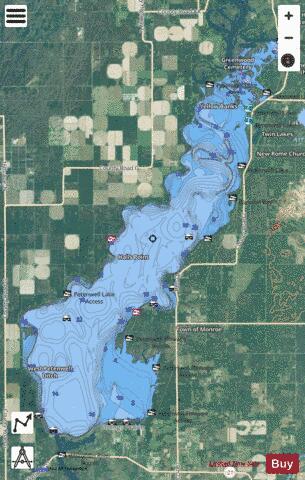
Lake Petenwell is an artificial lake on the Wisconsin River in central Wisconsin. It is located in Adams, Juneau, and Wood counties next to Castle Rock Lake. It covers over 23,000 acres (93 km2) and is 42 feet (13 m) deep. Lake Petenwell is Wisconsin's second largest lake at 23,040 acres (93.2 km2) or approximately 36 square miles (93 km2). It was created in 1948 by the Wisconsin River Power Company with the construction of a dam across the Wisconsin River near Necedah. It has a maximum depth of 42 feet (13 m) and is used for skiing, sailing and fishing. Private lakefront property is very limited as most of the virgin shoreline is undeveloped forest. Wildlife includes wintering bald eagles. Game fish include walleye, northern pike, bass, panfish, and muskellunge. The area around the lake has restaurants, a community theater, a golf course and two casinos.
More on Wikipedia...Popular fish species in this lake include Northern pike, Panfish and Walleye.
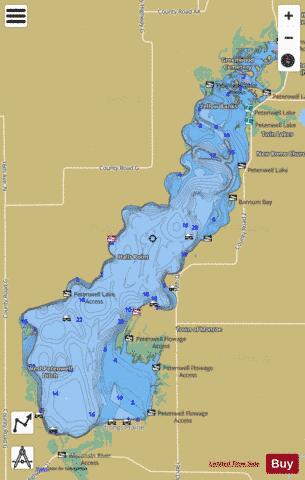
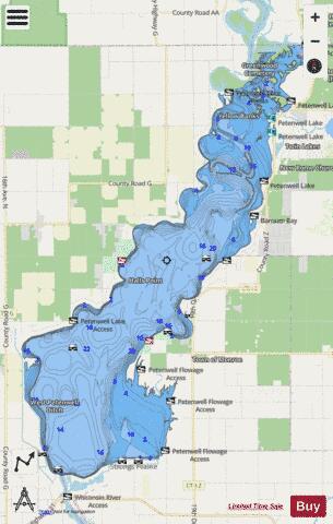
Petenwell Lake Fishing Map Stats | |
| Title | Petenwell Lake |
| Scale | 1:24000 |
| Counties | Adams, Juneau, Wood |
| Nearby Cities | Strongs Prairie, Monroe Center, Lake Arrowhead, Necedah, Nekoosa, Arkdale, Lake Sherwood, Dellwood, Port Edwards, Lake Camelot |
| Area * | 23017.25 acres |
| Shoreline * | 101.07 miles |
| Min Longitude | -90.05 |
| Min Latitude | 44.06 |
| Max Longitude | -89.87 |
| Max Latitude | 44.25 |
| Edition Label 1 | |
| Edition Label 2 | |
| Edition Label 3 | |
| Id | US_AA_WI_01571254 |
| Country | US |
| Projection | Mercator |
| * some Stats may include nearby/connecting waterbodies | |
|