Electric Lake fishing map is available as part of iBoating : USA Marine & Fishing App(now supported on multiple platforms including Android, iPhone/iPad, MacBook, and Windows(tablet and phone)/PC based chartplotter.).
With our Lake Maps App, you get all the great marine chart app features like fishing spots, along with Electric Lake depth map. The fishing maps app include HD lake depth contours, along with advanced features found in Fish Finder / Gps Chart Plotter systems, turning your device into a Depth Finder. The Electric Lake Navigation App provides advanced features of a Marine Chartplotter including adjusting water level offset and custom depth shading. Fishing spots and depth contours layers are available in most Lake maps. Lake navigation features include advanced instrumentation to gather wind speed direction, water temperature, water depth, and accurate GPS with AIS receivers(using NMEA over TCP/UDP). Autopilot support can be enabled during ‘Goto WayPoint’ and ‘Route Assistance’.
Now i-Boating supports Fishing Points in Electric Lake.
Have more questions about the Nautical Chart App? Ask us.
Fishing Info for Electric Lake
Electric Lake is a large reservoir on Huntington Creek high on the east slope of the Wasatch Plateau in Utah. The reservoir was created in 1974 by the construction of an earth-fill dam. The shoreline is primarily owned by Utah Power and Light (UP&L) and the Huntington-Cleveland Irrigation Company. Access is limited but the northern end of the reservoir is adjacent to the national forest and access is unrestricted at that point.
More on Wikipedia...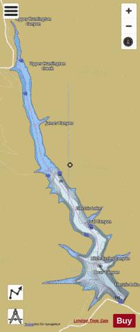
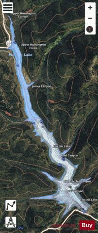
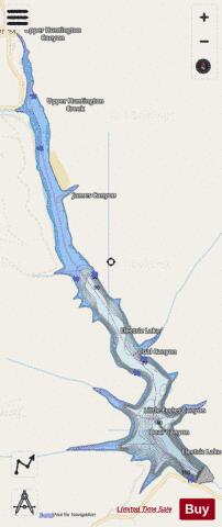
Electric Lake Fishing Map Stats | |
| Title | Electric Lake |
| Scale | 1:12000 |
| Counties | Emery |
| Nearby Cities | Clear Creek, Scofield, Milburn, Fairview, Wattis, Mount Pleasant, Hiawatha, Gilluly, Spring City, Indianola |
| Area * | 468.84 acres |
| Shoreline * | 12.48 miles |
| Min Longitude | -111.24 |
| Min Latitude | 39.60 |
| Max Longitude | -111.21 |
| Max Latitude | 39.65 |
| Edition Label 1 | |
| Edition Label 2 | |
| Edition Label 3 | |
| Id | US_AA_UT_01447801 |
| Country | US |
| Projection | Mercator |
| * some Stats may include nearby/connecting waterbodies | |
|