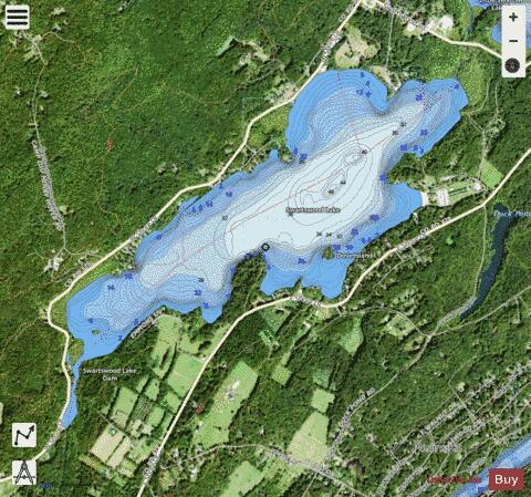
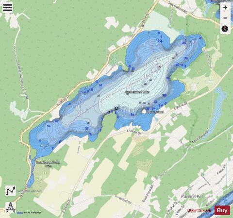
Swartswood Lake fishing map is available as part of iBoating : USA Marine & Fishing App(now supported on multiple platforms including Android, iPhone/iPad, MacBook, and Windows(tablet and phone)/PC based chartplotter.).
With our Lake Maps App, you get all the great marine chart app features like fishing spots, along with Swartswood Lake depth map. The fishing maps app include HD lake depth contours, along with advanced features found in Fish Finder / Gps Chart Plotter systems, turning your device into a Depth Finder. The Swartswood Lake Navigation App provides advanced features of a Marine Chartplotter including adjusting water level offset and custom depth shading. Fishing spots and depth contours layers are available in most Lake maps. Lake navigation features include advanced instrumentation to gather wind speed direction, water temperature, water depth, and accurate GPS with AIS receivers(using NMEA over TCP/UDP). Autopilot support can be enabled during ‘Goto WayPoint’ and ‘Route Assistance’.
Now i-Boating supports Fishing Points in Swartswood Lake.
Have more questions about the Nautical Chart App? Ask us.
Fishing Info for Swartswood Lake
Swartswood Lake (previously called Swartout's Pond) is a freshwater lake located in Stillwater and Hampton townships in Sussex County, New Jersey in the United States. The lake is a 520-acre (210 ha) glacial lake that is the third-largest freshwater lake in New Jersey. The lake stretches 3 miles (4.8 km) (north-to-south) and 1 mile (1.6 km) wide (east to west); and has an average depth of 22 feet (6.7 m) with a maximum depth of 42 feet (13 m). The lake is the focus of Swartswood State Park a 3,460-acre (14.0 km2) protected area administered by the New Jersey Division of Parks and Forestry. Swartswood Lake is fed by the waters of Neldon's Brook (draining several lakes and Bear Swamp in Stillwater, Hampton, and Frankford townships; and by Indian Creek (or River) which empties Little Swartswood Lake to the north. The southern end of the lake was dammed by Charles Rhodes, Sr., in 1790 forming a mill pond in the narrow ravine at the lake's outlet, Keen's Mill Brook. The Brook flows into the Trout Brook near Middleville in Stillwater Township, a tributary of the Paulins Kill.
More on Wikipedia...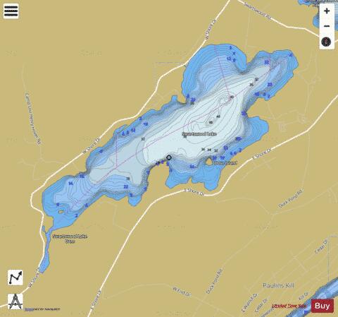
Swartswood Lake Fishing Map Stats | |
| Title | Swartswood Lake |
| Scale | 1:12000 |
| Counties | Sussex |
| Nearby Cities | Crandon Lakes, Newton, Marksboro, Branchville, Johnsonburg, Augusta, Ross Corner, Andover, Blairstown, Lafayette |
| Area * | 521.04 acres |
| Shoreline * | 7.23 miles |
| Min Longitude | -74.85 |
| Min Latitude | 41.06 |
| Max Longitude | -74.82 |
| Max Latitude | 41.08 |
| Edition Label 1 | |
| Edition Label 2 | |
| Edition Label 3 | |
| Id | US_AA_NJ_00881045 |
| Country | US |
| Projection | Mercator |
| * some Stats may include nearby/connecting waterbodies | |
|