Lake Freeman fishing map is available as part of iBoating : USA Marine & Fishing App(now supported on multiple platforms including Android, iPhone/iPad, MacBook, and Windows(tablet and phone)/PC based chartplotter.).
With our Lake Maps App, you get all the great marine chart app features like fishing spots, along with Lake Freeman depth map. The fishing maps app include HD lake depth contours, along with advanced features found in Fish Finder / Gps Chart Plotter systems, turning your device into a Depth Finder. The Lake Freeman Navigation App provides advanced features of a Marine Chartplotter including adjusting water level offset and custom depth shading. Fishing spots and depth contours layers are available in most Lake maps. Lake navigation features include advanced instrumentation to gather wind speed direction, water temperature, water depth, and accurate GPS with AIS receivers(using NMEA over TCP/UDP). Autopilot support can be enabled during ‘Goto WayPoint’ and ‘Route Assistance’.
Now i-Boating supports Fishing Points in Lake Freeman.
Have more questions about the Nautical Chart App? Ask us.
Fishing Info for Lake Freeman
Lake Freeman is a reservoir outside of Monticello, Indiana formed in 1925 by the completion of the Oakdale Dam. Lake Freeman, together with its sister lake, Lake Shafer is part of the Twin Lakes region, a popular summer recreational area centered on the town of Monticello, Indiana. Construction of the Oakdale Dam began in 1923 and was completed in 1925, damming the waters of the Tippecanoe River. The earthen dam is 58 feet high, has a maximum capacity of 40,540 acre-feet, normal capacity of 26,140 acre feet, and is owned by the Northern Indiana Public Service Company. Compared to the more commercial lake, Lake Shafer, Lake Freeman remains more privatized and residential. Lake Freeman, is however, home of the Madam Carroll, a pleasure excursion vessel, 36 feet (5.5 m) in width and 135 feet (41/5) in length. Lake Freeman is roughly 1,500 acres (6 km²) in area and has a shoreline of 50 miles (80 km). Depths vary from 7 feet (2 m) to 45 feet (15 m) at the Oakdale Dam. According to his widow, it was named for Rhode Island civil engineer Roger Morse Freeman who was involved in many well known projects; his father John R. Freeman, who he started his career with, was an internationally known engineer. Freeman Lacus on Titan is named after Lake Freeman.
More on Wikipedia...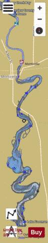
Lake Freeman Fishing Map Stats | |
| Title | Lake Freeman |
| Sailing Clubs in this Chart region | |
| Lafayette Sailing Club | |
| Scale | 1:3000 |
| Counties | Carroll, White |
| Nearby Cities | Norway, Monticello, Yeoman, Idaville, Buffalo, Delphi, Chalmers, Reynolds, Brookston, Americus |
| Area * | 1569.20 acres |
| Shoreline * | 36.86 miles |
| Min Longitude | -86.77 |
| Min Latitude | 40.66 |
| Max Longitude | -86.74 |
| Max Latitude | 40.78 |
| Edition Label 1 | |
| Edition Label 2 | |
| Edition Label 3 | |
| Id | US_AA_IN_freeman_il |
| Country | US |
| Projection | Mercator |
| * some Stats may include nearby/connecting waterbodies | |
|