Taylorville Lake fishing map is available as part of iBoating : USA Marine & Fishing App(now supported on multiple platforms including Android, iPhone/iPad, MacBook, and Windows(tablet and phone)/PC based chartplotter.).
With our Lake Maps App, you get all the great marine chart app features like fishing spots, along with Taylorville Lake depth map. The fishing maps app include HD lake depth contours, along with advanced features found in Fish Finder / Gps Chart Plotter systems, turning your device into a Depth Finder. The Taylorville Lake Navigation App provides advanced features of a Marine Chartplotter including adjusting water level offset and custom depth shading. Fishing spots and depth contours layers are available in most Lake maps. Lake navigation features include advanced instrumentation to gather wind speed direction, water temperature, water depth, and accurate GPS with AIS receivers(using NMEA over TCP/UDP). Autopilot support can be enabled during ‘Goto WayPoint’ and ‘Route Assistance’.
Now i-Boating supports Fishing Points in Taylorville Lake.
Have more questions about the Nautical Chart App? Ask us.
Fishing Info for Taylorville Lake
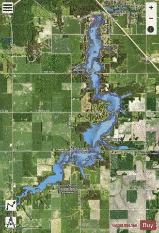
Lake Taylorville is a 1,200-acre (4.8 km²) reservoir located in Christian County, Illinois. Created in 1962 by damming the South Fork of Illinois's Sangamon River, it was built for water supply and recreation purposes. The lake is 6.5 miles (10.5 km) long and 0.4 miles (0.6 km) wide. The nearest town is Taylorville, Illinois, southeast of Springfield, Illinois. Lake Taylorville is managed by the city of Taylorville. As with other Central Illinois reservoirs, Lake Taylorville is troubled by siltation, with an estimated 90,000 tons of silt annually eroding from farms in the lake's South Fork of the Sangamon catchment area and washing into the lake. The city in 1998 built a low-headed silt dam on Locust Creek, one of the reservoir's tributaries, to reduce lake siltation. In 2006, Taylorville City Council began to discuss the issue of dredging the lake to remove unwanted silt. The proposal has not been approved yet because of the large sum of money it would cost the city to dredge the lake. If this project were to take place it would be sometime in the fall of 2008 when the summer recreational season is over and before winter arrives.
More on Wikipedia...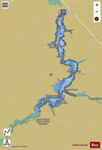
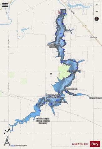
Taylorville Lake Fishing Map Stats | |
| Title | Taylorville Lake |
| Scale | 1:12000 |
| Counties | Christian |
| Nearby Cities | Owaneco, Taylorville, Langleyville, Palmer, Stonington, Wenonah, Ohlman, Jeisyville, Nokomis, Morrisonville |
| Area * | 1268.79 acres |
| Shoreline * | 31.89 miles |
| Min Longitude | -89.30 |
| Min Latitude | 39.45 |
| Max Longitude | -89.23 |
| Max Latitude | 39.53 |
| Edition Label 1 | |
| Edition Label 2 | |
| Edition Label 3 | |
| Id | US_AA_IL_taylorville_lake_il |
| Country | US |
| Projection | Mercator |
| * some Stats may include nearby/connecting waterbodies | |
|