Payette Lake fishing map is available as part of iBoating : USA Marine & Fishing App(now supported on multiple platforms including Android, iPhone/iPad, MacBook, and Windows(tablet and phone)/PC based chartplotter.).
With our Lake Maps App, you get all the great marine chart app features like fishing spots, along with Payette Lake depth map. The fishing maps app include HD lake depth contours, along with advanced features found in Fish Finder / Gps Chart Plotter systems, turning your device into a Depth Finder. The Payette Lake Navigation App provides advanced features of a Marine Chartplotter including adjusting water level offset and custom depth shading. Fishing spots and depth contours layers are available in most Lake maps. Lake navigation features include advanced instrumentation to gather wind speed direction, water temperature, water depth, and accurate GPS with AIS receivers(using NMEA over TCP/UDP). Autopilot support can be enabled during ‘Goto WayPoint’ and ‘Route Assistance’.
Now i-Boating supports Fishing Points in Payette Lake.
Have more questions about the Nautical Chart App? Ask us.
Fishing Info for Payette Lake
Payette Lake is a natural lake in the western United States, located in west central Idaho at McCall. Formed by glacial activity, it is situated in the upper drainage basin of the Payette River, which drains into the Snake River. Outflow from the lake at is regulated for irrigation purposes by a small dam completed in 1943. The normal maximum lake surface elevation of 4,990 feet (1,520 m) above sea level is attained in July; a normal drawdown of 5 feet 7 inches (1.7 m) is completed by December. The lake surface area and volume, excluding islands, are 7.9 square miles (20.5 km2) and 0.18 cubic miles (0.75 km3), respectively; mean and maximum depths are 121 feet (36.8 m) and 304 feet (92.7 m), respectively; and shoreline length is about 22 miles (36 km). The principal tributary and outlet is the North Fork Payette River. The lake receives drainage from 144 square miles (373 km2) of heavily forested, mountainous terrain. Further south, the North Fork flows into Lake Cascade, a reservoir behind Cascade Dam.
More on Wikipedia...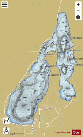
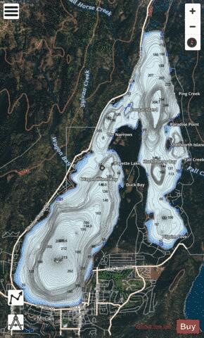
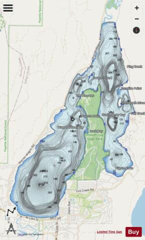
Payette Lake Fishing Map Stats | |
| Title | Payette Lake |
| Scale | 1:12000 |
| Counties | Valley |
| Nearby Cities | McCall, Lake Fork, Meadows, New Meadows, Donnelly, Burgdorf, Fruitvale, Council, Cascade, Pollock |
| Area * | 5074.67 acres |
| Shoreline * | 25.39 miles |
| Min Longitude | -116.13 |
| Min Latitude | 44.91 |
| Max Longitude | -116.05 |
| Max Latitude | 44.99 |
| Edition Label 1 | |
| Edition Label 2 | |
| Edition Label 3 | |
| Id | US_AA_ID_payette_lake_id |
| Country | US |
| Projection | Mercator |
| * some Stats may include nearby/connecting waterbodies | |
|