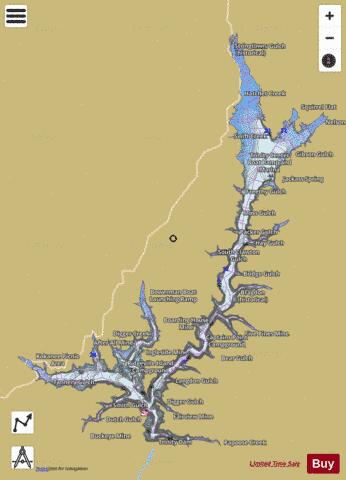
Trinity Lake fishing map is available as part of iBoating : USA Marine & Fishing App(now supported on multiple platforms including Android, iPhone/iPad, MacBook, and Windows(tablet and phone)/PC based chartplotter.).
With our Lake Maps App, you get all the great marine chart app features like fishing spots, along with Trinity Lake depth map. The fishing maps app include HD lake depth contours, along with advanced features found in Fish Finder / Gps Chart Plotter systems, turning your device into a Depth Finder. The Trinity Lake Navigation App provides advanced features of a Marine Chartplotter including adjusting water level offset and custom depth shading. Fishing spots and depth contours layers are available in most Lake maps. Lake navigation features include advanced instrumentation to gather wind speed direction, water temperature, water depth, and accurate GPS with AIS receivers(using NMEA over TCP/UDP). Autopilot support can be enabled during ‘Goto WayPoint’ and ‘Route Assistance’.
Now i-Boating supports Fishing Points in Trinity Lake.
Have more questions about the Nautical Chart App? Ask us.
Fishing Info for Trinity Lake
Trinity Lake, previously called Clair Engle Lake, is an artificial lake on the Trinity River formed by the Trinity Dam and located in Trinity County, California, United States. The dam was built by the U.S. Bureau of Reclamation. The lake's capacity is 2,447,650 acre⋅ft (3,019.13 GL), making it one of the largest reservoirs in California. The lake's surface is at 2,370 ft (720 m) above MSL. Trinity Lake captures and stores water for the Central Valley Project, which provides the Central Valley with water for irrigation and produces hydroelectric power. This lake is known for its many small arms, glassy inlets, and good water-skiing conditions. After the death in office of California United States Senator Clair Engle in 1964, the lake was renamed after him; however, the name change never received wide popularity, especially with locals, and the name was eventually returned to its frequently known original name. The lake is serviced by three marinas: Trinity Alps Marina located on the southern end in view of the Dam; Cedar Stock marina on the Stuart Fork arm on the west end of the lake; and Trinity Center marina at the northern end of the main arm of the lake. Most of the marinas rent houseboats to vacationers year round. Most marinas on the lake are now owned and operated by Forever Resorts, with the only exception being the Trinity Alps Marina.
More on Wikipedia...Popular fish species in this lake include Largemouth bass, Rainbow trout and Smallmouth bass.
Trinity Lake Fishing Map Stats | |
| Title | Trinity Lake |
| Scale | 1:12000 |
| Counties | Trinity |
| Nearby Cities | Trinity Center, Lewiston, French Gulch, Weaverville, Lamoine, Douglas City, Junction City, Lakehead, Helena, Callahan |
| Area * | 15586.54 acres |
| Shoreline * | 148.63 miles |
| Min Longitude | -122.87 |
| Min Latitude | 40.80 |
| Max Longitude | -122.62 |
| Max Latitude | 41.05 |
| Edition Label 1 | |
| Edition Label 2 | |
| Edition Label 3 | |
| Id | US_AA_CA_trinity_ca |
| Country | US |
| Projection | Mercator |
| * some Stats may include nearby/connecting waterbodies | |
|


