Salt Springs Reservoir fishing map is available as part of iBoating : USA Marine & Fishing App(now supported on multiple platforms including Android, iPhone/iPad, MacBook, and Windows(tablet and phone)/PC based chartplotter.).
With our Lake Maps App, you get all the great marine chart app features like fishing spots, along with Salt Springs Reservoir depth map. The fishing maps app include HD lake depth contours, along with advanced features found in Fish Finder / Gps Chart Plotter systems, turning your device into a Depth Finder. The Salt Springs Reservoir Navigation App provides advanced features of a Marine Chartplotter including adjusting water level offset and custom depth shading. Fishing spots and depth contours layers are available in most Lake maps. Lake navigation features include advanced instrumentation to gather wind speed direction, water temperature, water depth, and accurate GPS with AIS receivers(using NMEA over TCP/UDP). Autopilot support can be enabled during ‘Goto WayPoint’ and ‘Route Assistance’.
Now i-Boating supports Fishing Points in Salt Springs Reservoir.
Have more questions about the Nautical Chart App? Ask us.
Fishing Info for Salt Springs Reservoir
Salt Springs Reservoir is a reservoir in the eastern portions of Amador County and Calaveras County of California in the Sierra Nevada about 30 miles (48 km) east-northeast of Jackson. The reservoir is in the Eldorado National Forest at an elevation of 3,900 feet (1,200 m). The 141,900 acre-foot (175,000,000 m3) reservoir is formed by Salt Springs Dam on the North Fork of the Mokelumne River. The concrete-faced rock-fill dam is 332 feet (101 m) tall and was completed in 1931. It is owned by Pacific Gas and Electric and its sole purpose is hydroelectricity production, though limited recreation is available. A short pipeline from the reservoir conveys water to the 44 MW Salt Springs Powerhouse. Some of the water is returned to the river downstream, but much of it flows into the Tiger Creek Conduit, a concrete flume that moves water downstream for use in other powerhouses in PG&E's Mokelumne River Project (FERC Project 137). The dam has a history of settlement problems caused by poor consolidation of the rocks during construction. The concrete face has been cracked many times by the movement, causing leaks. The surface of the dam consists of cracks, craters and shotcrete overlays. It was decided to use a flexible geomembrane to cover the portions of the dam with the greatest leakage. The installation of the membrane was completed in 2005. The dam is being examined as the lower pool in a 380-1,140 MW pumped-storage project with the Bear River Dam as the upper pool.
More on Wikipedia...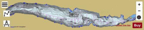
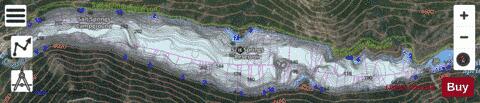
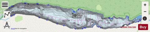
Salt Springs Reservoir Fishing Map Stats | |
| Title | Salt Springs Reservoir |
| Scale | 1:12000 |
| Counties | Amador, Calaveras |
| Nearby Cities | Bear Valley, Dorrington, Kirkwood, White Pines, Arnold, Kyburz, Buckhorn, Wilseyville, Strawberry, West Point |
| Area * | 917.64 acres |
| Shoreline * | 9.81 miles |
| Min Longitude | -120.22 |
| Min Latitude | 38.49 |
| Max Longitude | -120.14 |
| Max Latitude | 38.50 |
| Edition Label 1 | |
| Edition Label 2 | |
| Edition Label 3 | |
| Id | US_AA_CA_salt_springs_reservoir_ca |
| Country | US |
| Projection | Mercator |
| * some Stats may include nearby/connecting waterbodies | |
|