Lake Miramar fishing map is available as part of iBoating : USA Marine & Fishing App(now supported on multiple platforms including Android, iPhone/iPad, MacBook, and Windows(tablet and phone)/PC based chartplotter.).
With our Lake Maps App, you get all the great marine chart app features like fishing spots, along with Lake Miramar depth map. The fishing maps app include HD lake depth contours, along with advanced features found in Fish Finder / Gps Chart Plotter systems, turning your device into a Depth Finder. The Lake Miramar Navigation App provides advanced features of a Marine Chartplotter including adjusting water level offset and custom depth shading. Fishing spots and depth contours layers are available in most Lake maps. Lake navigation features include advanced instrumentation to gather wind speed direction, water temperature, water depth, and accurate GPS with AIS receivers(using NMEA over TCP/UDP). Autopilot support can be enabled during ‘Goto WayPoint’ and ‘Route Assistance’.
Now i-Boating supports Fishing Points in Lake Miramar.
Have more questions about the Nautical Chart App? Ask us.
Fishing Info for Lake Miramar
Miramar Reservoir is a reservoir located in the Scripps Miramar Ranch community of San Diego, California. Owned, operated and maintained by the City of San Diego, the reservoir and its 165-foot tall earthen embankment dam were completed in 1960 as part of the second San Diego Aqueduct project. Water flowing south to the reservoir originates from both the Colorado River Aqueduct and the California Aqueduct, brought into San Diego by the San Diego County Water Authority. The Miramar Reservoir is also a popular recreation site known as Lake Miramar or Miramar Lake to local residents. Activities include boating, fishing, picnicking, and the use of an over 5-mile-long trail wrapping around the lake. The stretch of the trail over the dam was fenced off for security reasons after the September 11, 2001 attacks, and reopened in 2007. This scenic stretch provides panoramic views of Mira Mesa, Miramar, University City, and other northern San Diego communities.
More on Wikipedia...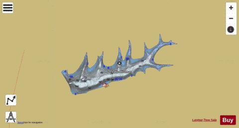
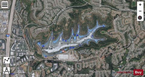
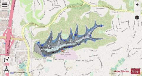
Lake Miramar Fishing Map Stats | |
| Title | Lake Miramar |
| Scale | 1:3000 |
| Counties | San Diego |
| Nearby Cities | Poway, Santee, Rancho Santa Fe, Eucalyptus Hills, Del Dios, La Mesa, Del Mar, Moreno, Grossmont, Riverview Farms |
| Area * | 145.15 acres |
| Shoreline * | 4.86 miles |
| Min Longitude | -117.11 |
| Min Latitude | 32.91 |
| Max Longitude | -117.09 |
| Max Latitude | 32.92 |
| Edition Label 1 | |
| Edition Label 2 | |
| Edition Label 3 | |
| Id | US_AA_CA_lake_miramar_ca |
| Country | US |
| Projection | Mercator |
| * some Stats may include nearby/connecting waterbodies | |
|