Lake Merced fishing map is available as part of iBoating : USA Marine & Fishing App(now supported on multiple platforms including Android, iPhone/iPad, MacBook, and Windows(tablet and phone)/PC based chartplotter.).
With our Lake Maps App, you get all the great marine chart app features like fishing spots, along with Lake Merced depth map. The fishing maps app include HD lake depth contours, along with advanced features found in Fish Finder / Gps Chart Plotter systems, turning your device into a Depth Finder. The Lake Merced Navigation App provides advanced features of a Marine Chartplotter including adjusting water level offset and custom depth shading. Fishing spots and depth contours layers are available in most Lake maps. Lake navigation features include advanced instrumentation to gather wind speed direction, water temperature, water depth, and accurate GPS with AIS receivers(using NMEA over TCP/UDP). Autopilot support can be enabled during ‘Goto WayPoint’ and ‘Route Assistance’.
Now i-Boating supports Fishing Points in Lake Merced.
Have more questions about the Nautical Chart App? Ask us.
Fishing Info for Lake Merced
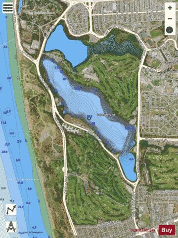
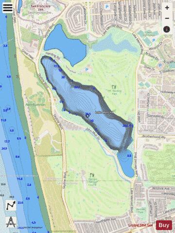
Lake Merced (Spanish: Laguna de Merced) is a freshwater lake in the southwest corner of San Francisco, in the U.S. state of California. It is surrounded by three golf courses (the private Olympic Club and San Francisco Golf Club, and the public TPC Harding Park), as well as residential areas, Lowell High School, San Francisco State University, Lakeshore Alternative Elementary School, Stonestown Galleria, Fort Funston and the Pacific Ocean. The San Francisco Police Department shooting range, as well as a now closed skeet shooting club and the city's National Guard armory are also in the area. The lake was also the home of the Lake Merced Sailing Club, now closed, which provided training and racing for local sailors. Currently there is a sailing and paddling program operated by San Francisco State University.[1] The lake is home of the Pacific Rowing Club and St. Ignatius College Prep Rowing Team, both competitive rowing programs for San Francisco high school students. The California Office of Environmental Health Hazard Assessment (OEHHA) has developed a safe eating advisory for Lake Merced based on levels of mercury found in fish caught from this water body.
More on Wikipedia...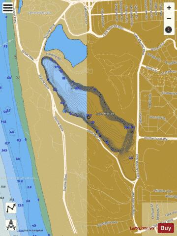
Lake Merced Fishing Map Stats | |
| Title | Lake Merced |
| Scale | 1:3000 |
| Counties | San Francisco |
| Nearby Cities | Broadmoor, Daly City, Colma, San Francisco, Pacifica, South San Francisco, San Bruno, Sausalito, Marin City, Brisbane |
| Area * | 207.68 acres |
| Shoreline * | 3.45 miles |
| Min Longitude | -122.50 |
| Min Latitude | 37.71 |
| Max Longitude | -122.49 |
| Max Latitude | 37.73 |
| Edition Label 1 | |
| Edition Label 2 | |
| Edition Label 3 | |
| Id | US_AA_CA_lake_merced__ca |
| Country | US |
| Projection | Mercator |
| * some Stats may include nearby/connecting waterbodies | |
|