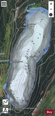
Fallen Leaf Lake fishing map is available as part of iBoating : USA Marine & Fishing App(now supported on multiple platforms including Android, iPhone/iPad, MacBook, and Windows(tablet and phone)/PC based chartplotter.).
With our Lake Maps App, you get all the great marine chart app features like fishing spots, along with Fallen Leaf Lake depth map. The fishing maps app include HD lake depth contours, along with advanced features found in Fish Finder / Gps Chart Plotter systems, turning your device into a Depth Finder. The Fallen Leaf Lake Navigation App provides advanced features of a Marine Chartplotter including adjusting water level offset and custom depth shading. Fishing spots and depth contours layers are available in most Lake maps. Lake navigation features include advanced instrumentation to gather wind speed direction, water temperature, water depth, and accurate GPS with AIS receivers(using NMEA over TCP/UDP). Autopilot support can be enabled during ‘Goto WayPoint’ and ‘Route Assistance’.
Now i-Boating supports Fishing Points in Fallen Leaf Lake.
Have more questions about the Nautical Chart App? Ask us.
Fishing Info for Fallen Leaf Lake
Fallen Leaf Lake is a mountain lake located in El Dorado County, California, near the California–Nevada state border, about one mile south west of the much larger Lake Tahoe. It is approximately aligned north-to-south and oval in shape, measuring approximately 2.9 miles (4.6 km) on the long axis and 0.9 miles (1.4 km) on the short axis. The lake was created by at least two glaciers that traveled northward down the Glen Alpine Valley. If the glacier had continued instead of stopping, Fallen Leaf Lake would be a bay of Lake Tahoe, similar to nearby Emerald Bay. A terminal moraine is visible at the north end of the lake on the northeast edge.
More on Wikipedia...Popular fish species in this lake include Lake trout and Rainbow trout.
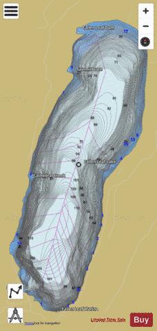

Fallen Leaf Lake Fishing Map Stats | |
| Title | Fallen Leaf Lake |
| Scale | 1:6000 |
| Counties | El Dorado |
| Nearby Cities | South Lake Tahoe, Stateline, Zephyr Cove, Meeks Bay, Skyland, Lakeridge, Tahoma, Kirkwood, Glenbrook, Genoa |
| Area * | 1408.94 acres |
| Shoreline * | 7.32 miles |
| Min Longitude | -120.07 |
| Min Latitude | 38.88 |
| Max Longitude | -120.05 |
| Max Latitude | 38.92 |
| Edition Label 1 | |
| Edition Label 2 | |
| Edition Label 3 | |
| Id | US_AA_CA_fallen_leaf_lake_ca |
| Country | US |
| Projection | Mercator |
| * some Stats may include nearby/connecting waterbodies | |
|