Parker Canyon Lake fishing map is available as part of iBoating : USA Marine & Fishing App(now supported on multiple platforms including Android, iPhone/iPad, MacBook, and Windows(tablet and phone)/PC based chartplotter.).
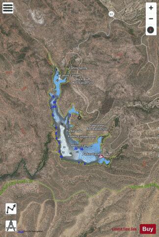
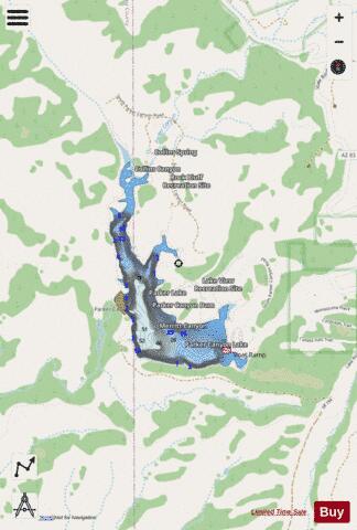
With our Lake Maps App, you get all the great marine chart app features like fishing spots, along with Parker Canyon Lake depth map. The fishing maps app include HD lake depth contours, along with advanced features found in Fish Finder / Gps Chart Plotter systems, turning your device into a Depth Finder. The Parker Canyon Lake Navigation App provides advanced features of a Marine Chartplotter including adjusting water level offset and custom depth shading. Fishing spots and depth contours layers are available in most Lake maps. Lake navigation features include advanced instrumentation to gather wind speed direction, water temperature, water depth, and accurate GPS with AIS receivers(using NMEA over TCP/UDP). Autopilot support can be enabled during ‘Goto WayPoint’ and ‘Route Assistance’.
Now i-Boating supports Fishing Points in Parker Canyon Lake.
Have more questions about the Nautical Chart App? Ask us.
Fishing Info for Parker Canyon Lake
Parker Canyon Lake is located in southeastern Arizona, 28 miles (45 km) southwest of Sierra Vista around the Huachuca Mountains and about 5 miles (8.0 km) north of the border with Mexico. The lake is a reservoir formed by a dam in Parker Canyon in the south end of the Canelo Hills in southwestern Cochise County. Parker Canyon is a tributary to the Santa Cruz River in the San Rafael Valley. The facilities are maintained by Coronado National Forest division of the USDA Forest Service.
More on Wikipedia...Popular fish species in this lake include Black bullhead, Fathead minnow, Green sunfish, Largemouth bass, Mosquitofish, Northern pike, Rainbow trout, Redear sunfish, Threadfin shad and Yellow bullhead.
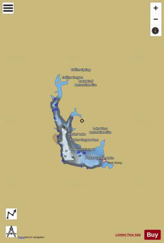
Parker Canyon Lake Fishing Map Stats | |
| Title | Parker Canyon Lake |
| Scale | 1:1500 |
| Counties | Cochise |
| Nearby Cities | Lochiel, Sierra Vista, Nicksville, Huachuca City, Sierra Vista Southeast, Elgin, Miracle Valley, Sonoita, Patagonia, Palominas |
| Area * | 105.32 acres |
| Shoreline * | 4.12 miles |
| Min Longitude | -110.46 |
| Min Latitude | 31.42 |
| Max Longitude | -110.45 |
| Max Latitude | 31.44 |
| Edition Label 1 | |
| Edition Label 2 | |
| Edition Label 3 | |
| Id | US_AA_AZ_parker_canyon_lake_az |
| Country | US |
| Projection | Mercator |
| * some Stats may include nearby/connecting waterbodies | |
|