Lake Bear fishing map is available as part of iBoating : USA Marine & Fishing App(now supported on multiple platforms including Android, iPhone/iPad, MacBook, and Windows(tablet and phone)/PC based chartplotter.).
With our Lake Maps App, you get all the great marine chart app features like fishing spots, along with Lake Bear depth map. The fishing maps app include HD lake depth contours, along with advanced features found in Fish Finder / Gps Chart Plotter systems, turning your device into a Depth Finder. The Lake Bear Navigation App provides advanced features of a Marine Chartplotter including adjusting water level offset and custom depth shading. Fishing spots and depth contours layers are available in most Lake maps. Lake navigation features include advanced instrumentation to gather wind speed direction, water temperature, water depth, and accurate GPS with AIS receivers(using NMEA over TCP/UDP). Autopilot support can be enabled during ‘Goto WayPoint’ and ‘Route Assistance’.
Now i-Boating supports Fishing Points in Lake Bear.
Have more questions about the Nautical Chart App? Ask us.
Fishing Info for Lake Bear
Bear Lake (one of a dozen lakes by this name in Alaska) is near the town of Seward and Resurrection Bay, in the Kenai Peninsula Borough on the Kenai Peninsula in the U.S. state of Alaska. It is accessible from Bear Creek Road, which connects it to the Seward Highway. It is the site of salmon enhancement activities since 1962. This program is now managed by the Cook Inlet Aquaculture Association.Current projects at Bear Lake focus on increasing sockeye and coho salmon by controlling species that are predators and competitors. The Bear Lake Formation provides scientists with important geological information about the Miocene environment.
More on Wikipedia...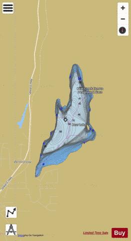
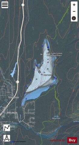
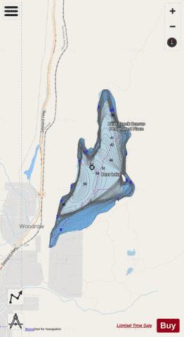
Lake Bear Fishing Map Stats | |
| Title | Lake Bear |
| Scale | 1:6000 |
| Counties | Kenai Peninsula |
| Nearby Cities | Seward, Moose Pass, Silvertip, Cooper Landing, Girdwood, Hope, Whittier |
| Area * | 418.78 acres |
| Shoreline * | 4.96 miles |
| Min Longitude | -149.37 |
| Min Latitude | 60.19 |
| Max Longitude | -149.34 |
| Max Latitude | 60.21 |
| Edition Label 1 | |
| Edition Label 2 | |
| Edition Label 3 | |
| Id | US_AA_AK_lake_bear_ak |
| Country | US |
| Projection | Mercator |
| * some Stats may include nearby/connecting waterbodies | |
|