Trekanten fishing map is included in Sweden - Stockholm Lakes nautical charts folio. It is available as part of iBoating : Inland Europe Marine & Fishing App (now supported on multiple platforms including Android, iPhone/iPad, MacBook, and Windows(tablet and phone)/PC based chartplotter. ).
With our Lake Maps App, you get all the great marine chart app features like fishing spots, along with Trekanten lake depth map. The fishing maps app include HD lake depth contours, along with advanced features found in Fish Finder / Gps Chart Plotter systems, turning your device into a Depth Finder. The Trekanten Navigation App provides advanced features of a Marine Chartplotter including adjusting water level offset and custom depth shading. Fishing spots and depth contours layers are available in most Lake maps. Lake navigation features include advanced instrumentation to gather wind speed direction, water temperature, water depth, and accurate GPS with AIS receivers(using NMEA over TCP/UDP). Autopilot support can be enabled during ‘Goto WayPoint’ and ‘Route Assistance’.
Have more questions about the Nautical Chart App? Ask us.
Fishing Info for Trekanten
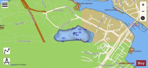
Trekanten (English: The Triangle) is a small lake in southern-central Stockholm, Sweden. Trekanten is located in a park furnished with an artificial bathing beach and various planted-out fish species. It has a small drainage area with no major feeders. In the early 1980s, potable water was poured into the lake while water from the bottom of the lake was pumped out. These operations resulted in a significant reduction in levels of phosphorus but failed to affect levels of nutrients and oxygen depletion in the bottom layers. Levels of lead and copper are among the highest documented in any lake in Stockholm. Whilst the lake flora and fauna is roughly representative for Stockholm, the lake forms a natural link between the bays Årstaviken and Vinterviken.
More on Wikipedia...Popular fish species in this lake include Northern pike, Rainbow trout and Rutilus.
Trekanten Fishing Map Stats | |
| Title | Trekanten |
| Scale | 1:6000 |
| Area * | 31.78 acres |
| Shoreline * | 1.02 miles |
| Min Longitude | 18.01 |
| Min Latitude | 59.31 |
| Max Longitude | 18.02 |
| Max Latitude | 59.31 |
| Edition Label 1 | |
| Edition Label 2 | |
| Edition Label 3 | |
| Id | II_SE_657902_162594_se |
| Country | Inland Europe |
| Projection | Mercator |
| * some Stats may include nearby/connecting waterbodies | |
|