Sicklasjön fishing map is included in Sweden - Stockholm Lakes nautical charts folio. It is available as part of iBoating : Inland Europe Marine & Fishing App (now supported on multiple platforms including Android, iPhone/iPad, MacBook, and Windows(tablet and phone)/PC based chartplotter. ).
With our Lake Maps App, you get all the great marine chart app features like fishing spots, along with Sicklasjön lake depth map. The fishing maps app include HD lake depth contours, along with advanced features found in Fish Finder / Gps Chart Plotter systems, turning your device into a Depth Finder. The Sicklasjön Navigation App provides advanced features of a Marine Chartplotter including adjusting water level offset and custom depth shading. Fishing spots and depth contours layers are available in most Lake maps. Lake navigation features include advanced instrumentation to gather wind speed direction, water temperature, water depth, and accurate GPS with AIS receivers(using NMEA over TCP/UDP). Autopilot support can be enabled during ‘Goto WayPoint’ and ‘Route Assistance’.
Have more questions about the Nautical Chart App? Ask us.
Fishing Info for Sicklasjön
Sicklasjön (Swedish: "Lake of Sickla") is a lake in eastern central Stockholm, Sweden. It is bordering the municipalities of Stockholm and Nacka and is named for the vicinity to the urban district Sickla. Sicklasjön, historically known as Långsjön ("Long Lake"), is connected to Järlasjön east of it through a narrow strait and to Hammarby Sjö west of it through the canal and the sluice . The lake, forming the northern border of the (Nacka friluftsområde, colloquially known as Nackareservatet, "Nacka [Nature] Reserve"), is considered as of significant recreational and natural value. Water flow is periodically important but inconsiderable during summers when the lake remains relatively stratified.
More on Wikipedia...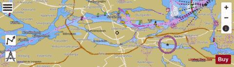
Sicklasjön Fishing Map Stats | |
| Title | Sicklasjön |
| Scale | 1:24000 |
| Area * | 1495.45 acres |
| Shoreline * | 36.92 miles |
| Min Longitude | 17.99 |
| Min Latitude | 59.30 |
| Max Longitude | 18.16 |
| Max Latitude | 59.32 |
| Edition Label 1 | |
| Edition Label 2 | |
| Edition Label 3 | |
| Id | II_SE_657800_163124_se |
| Country | Inland Europe |
| Projection | Mercator |
| * some Stats may include nearby/connecting waterbodies | |
|