Lindores Loch (Tay Basin) fishing map is included in Scotland - Fife Lochs nautical charts folio. It is available as part of iBoating : Inland Europe Marine & Fishing App (now supported on multiple platforms including Android, iPhone/iPad, MacBook, and Windows(tablet and phone)/PC based chartplotter. ).
With our Lake Maps App, you get all the great marine chart app features like fishing spots, along with Lindores Loch (Tay Basin) lake depth map. The fishing maps app include HD lake depth contours, along with advanced features found in Fish Finder / Gps Chart Plotter systems, turning your device into a Depth Finder. The Lindores Loch (Tay Basin) Navigation App provides advanced features of a Marine Chartplotter including adjusting water level offset and custom depth shading. Fishing spots and depth contours layers are available in most Lake maps. Lake navigation features include advanced instrumentation to gather wind speed direction, water temperature, water depth, and accurate GPS with AIS receivers(using NMEA over TCP/UDP). Autopilot support can be enabled during ‘Goto WayPoint’ and ‘Route Assistance’.
Have more questions about the Nautical Chart App? Ask us.
Fishing Info for Lindores Loch (Tay Basin)
Lindores Loch is a freshwater loch, situated in North Fife in the Parish of Abdie, in the Central Belt of Scotland. The Loch has for many years been used as a fishery and is well known for its abundant fish life. A curling pond is situated on the Northern shoreline and is nominally used by the Abdie Curling Club and Abdie ladies Curling Club. A speculative study suggests that the loch was created by glacial deposits from the surrounding Ochil Hills at the end of the last ice-age. The water level and shoreline have changed over time due to roads, railway, sluice gate and farmland.
More on Wikipedia...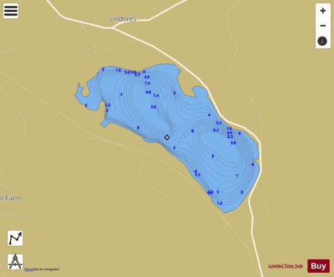
Lindores Loch (Tay Basin) Fishing Map Stats | |
| Title | Lindores Loch (Tay Basin) |
| Scale | 1:6000 |
| Area * | 90.89 acres |
| Shoreline * | 2.14 miles |
| Min Longitude | -3.19 |
| Min Latitude | 56.33 |
| Max Longitude | -3.18 |
| Max Latitude | 56.34 |
| Edition Label 1 | |
| Edition Label 2 | |
| Edition Label 3 | |
| Id | II_SCOT_74422358_0_scot |
| Country | Inland Europe |
| Projection | Mercator |
| * some Stats may include nearby/connecting waterbodies | |
| ||||||||||||||||||||||||||||||||||||||||||||||||||||||||||||||||||||||||||||||||||||||||||||||||||||||||
|