Loch Leven fishing map is included in Scotland - Perthshire and Kinross Lochs nautical charts folio. It is available as part of iBoating : Inland Europe Marine & Fishing App (now supported on multiple platforms including Android, iPhone/iPad, MacBook, and Windows(tablet and phone)/PC based chartplotter. ).
With our Lake Maps App, you get all the great marine chart app features like fishing spots, along with Loch Leven lake depth map. The fishing maps app include HD lake depth contours, along with advanced features found in Fish Finder / Gps Chart Plotter systems, turning your device into a Depth Finder. The Loch Leven Navigation App provides advanced features of a Marine Chartplotter including adjusting water level offset and custom depth shading. Fishing spots and depth contours layers are available in most Lake maps. Lake navigation features include advanced instrumentation to gather wind speed direction, water temperature, water depth, and accurate GPS with AIS receivers(using NMEA over TCP/UDP). Autopilot support can be enabled during ‘Goto WayPoint’ and ‘Route Assistance’.
Have more questions about the Nautical Chart App? Ask us.
Fishing Info for Loch Leven
Loch Leven (Scottish Gaelic: Loch Lìobhann) is a fresh water loch located immediately to the east of the burgh of Kinross in Perth and Kinross council area, central Scotland. Roughly triangular, the loch is about 6 km (3.7 mi) at its longest. Prior to the canalisation of the River Leven, and the partial draining of the loch in 1826–36, Loch Leven was considerably larger. The drop in water level by 1.4 m (4 ft 7 in) reduced the loch to 75% of its former size, and exposed several small islands, as well as greatly increasing the size of the existing ones. There are seven islands on the loch, the largest being St Serf's Inch. Loch Leven Castle, where Mary, Queen of Scots was imprisoned in 1567, lies on one of these islands, and it can be reached by a ferry operated from Kinross by Historic Environment Scotland during the summer months. NatureScot describe Loch Leven as "one of Scotland's top natural assets", due to its rich ecosystem that supports many different species of plants, insects, fish and birds. It is of particular significance to migrating birds, who use it as a stopover when flying between their breeding and wintering grounds, due to its lowland location, shallow nutrient rich waters, large water surface, and islands (which provide safe nesting sites). Loch Leven holds numerous national and international conservation designations, including being a national nature reserve (NNR).
More on Wikipedia...Popular fish species in this lake include Arctic char and Atlantic salmon.
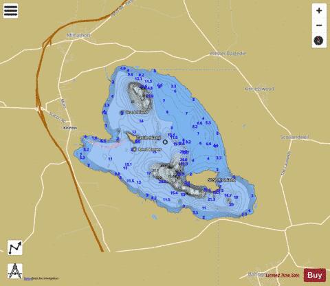
Loch Leven Fishing Map Stats | |
| Title | Loch Leven |
| Scale | 1:24000 |
| Area * | 3395.85 acres |
| Shoreline * | 16.28 miles |
| Min Longitude | -3.42 |
| Min Latitude | 56.18 |
| Max Longitude | -3.33 |
| Max Latitude | 56.22 |
| Edition Label 1 | |
| Edition Label 2 | |
| Edition Label 3 | |
| Id | II_SCOT_74422112_0_scot |
| Country | Inland Europe |
| Projection | Mercator |
| * some Stats may include nearby/connecting waterbodies | |
| ||||||||||||||||||||||||||||||||||||||||||||||||||||||||||||||||||||||||||||||||||||||||||||||||||||||||
|