Kilconquhar Loch (Forth Basin) fishing map is included in Scotland - Fife Lochs nautical charts folio. It is available as part of iBoating : Inland Europe Marine & Fishing App (now supported on multiple platforms including Android, iPhone/iPad, MacBook, and Windows(tablet and phone)/PC based chartplotter. ).
With our Lake Maps App, you get all the great marine chart app features like fishing spots, along with Kilconquhar Loch (Forth Basin) lake depth map. The fishing maps app include HD lake depth contours, along with advanced features found in Fish Finder / Gps Chart Plotter systems, turning your device into a Depth Finder. The Kilconquhar Loch (Forth Basin) Navigation App provides advanced features of a Marine Chartplotter including adjusting water level offset and custom depth shading. Fishing spots and depth contours layers are available in most Lake maps. Lake navigation features include advanced instrumentation to gather wind speed direction, water temperature, water depth, and accurate GPS with AIS receivers(using NMEA over TCP/UDP). Autopilot support can be enabled during ‘Goto WayPoint’ and ‘Route Assistance’.
Have more questions about the Nautical Chart App? Ask us.
Fishing Info for Kilconquhar Loch (Forth Basin)
Kilconquhar Loch /kɪˈnjʌxər lɒx/ is a Scottish freshwater loch. This small shallow loch is a Site of Special Scientific Interest (SSSI) and is located beside the village of the same name in the east of Fife, within a mile to the north of the coastal village of Elie. The loch appears to be a comparatively recent feature, the earliest reference being to "the gret loch callit of auld the Reidmyre" (Scots: red or reed peat bog) in 1599 and referred to as Keanwchar Loch by 1654 in Blaeu's Atlas Novus. Samples of the loch bed support its origin as a bog and there is archaeological evidence and a local tradition that fuel was extracted. Westward outflow to the Cocklemill Burn is said to have been blocked by sand in 1624 or 1625 but it is drained to the south-east by the largely underground Loch Run into Elie harbour and eastwards to the Inverie Burn. It is an approximate rounded square in shape, and is unusual in that it has no visible inflow, yet is not stagnant. It is the subject of a study by St. Andrews University. It has been theorised that an underground spring feeds into the loch, maintaining a degree of freshness sufficient to offset its stagnation. In former times it was reported to produce large pike and eels, although this is now no longer verifiable as no fishing is allowed, due to its SSSI status. Large numbers of overwintering wildfowl use Kilconquhar Loch as a roost. It was charted during the Bathymetrical Survey of the Fresh-Water Lochs of Scotland, constructed under the direction of Sir John Murray and Laurence Pullar during the years 1897 to 1909.
More on Wikipedia...Popular fish species in this lake include Esox.
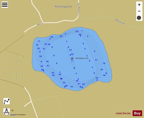
Kilconquhar Loch (Forth Basin) Fishing Map Stats | |
| Title | Kilconquhar Loch (Forth Basin) |
| Scale | 1:6000 |
| Area * | 78.17 acres |
| Shoreline * | 1.36 miles |
| Min Longitude | -2.83 |
| Min Latitude | 56.20 |
| Max Longitude | -2.82 |
| Max Latitude | 56.21 |
| Edition Label 1 | |
| Edition Label 2 | |
| Edition Label 3 | |
| Id | II_SCOT_74422357_0_scot |
| Country | Inland Europe |
| Projection | Mercator |
| * some Stats may include nearby/connecting waterbodies | |
| ||||||||||||||||||||||||||||||||||||||||||||||||||||||||||||||||||||||||||||||||||||||||||||||||||||||||
|