Loch Frisa (Mull) fishing map is included in Scotland - Argyll and Bute Lochs nautical charts folio. It is available as part of iBoating : Inland Europe Marine & Fishing App (now supported on multiple platforms including Android, iPhone/iPad, MacBook, and Windows(tablet and phone)/PC based chartplotter. ).
With our Lake Maps App, you get all the great marine chart app features like fishing spots, along with Loch Frisa (Mull) lake depth map. The fishing maps app include HD lake depth contours, along with advanced features found in Fish Finder / Gps Chart Plotter systems, turning your device into a Depth Finder. The Loch Frisa (Mull) Navigation App provides advanced features of a Marine Chartplotter including adjusting water level offset and custom depth shading. Fishing spots and depth contours layers are available in most Lake maps. Lake navigation features include advanced instrumentation to gather wind speed direction, water temperature, water depth, and accurate GPS with AIS receivers(using NMEA over TCP/UDP). Autopilot support can be enabled during ‘Goto WayPoint’ and ‘Route Assistance’.
Have more questions about the Nautical Chart App? Ask us.
Fishing Info for Loch Frisa (Mull)
Loch Frisa is a loch (lake) on the Isle of Mull, Inner Hebrides, Scotland. It falls within the Argyll and Bute unitary authority area. The loch runs largely northwest to southeast. Its northwestern end is about halfway between Tobermory and Dervaig. It is the largest loch on the Isle of Mull. Loch Frisa is considered to be low-altitude, medium-alkalinity and generally deep. It is known for eagle watching. The ship HMS Widemouth Bay was for some time named after Loch Frisa, and Caledonian Maritime Assets purchased a ferry in 2021 that they named MV Loch Frisa.
More on Wikipedia...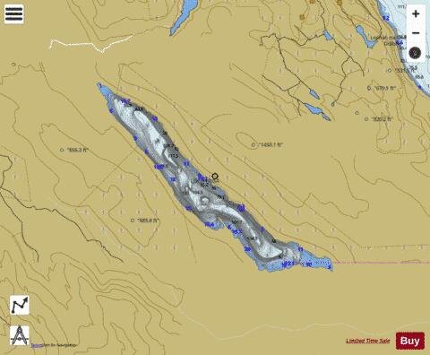
Loch Frisa (Mull) Fishing Map Stats | |
| Title | Loch Frisa (Mull) |
| Scale | 1:12000 |
| Area * | 1091.63 acres |
| Shoreline * | 10.83 miles |
| Min Longitude | -6.13 |
| Min Latitude | 56.55 |
| Max Longitude | -6.04 |
| Max Latitude | 56.59 |
| Edition Label 1 | |
| Edition Label 2 | |
| Edition Label 3 | |
| Id | II_SCOT_74422337_0_scot |
| Country | Inland Europe |
| Projection | Mercator |
| * some Stats may include nearby/connecting waterbodies | |
| |||||||||||||||||||||||||||||||||||||||||||||||||||||||||||||||||||||||||||||||||||||||||||||||||||||||
|