Loch Doire Nam Mart fishing map is included in Scotland - Highland Lochs nautical charts folio. It is available as part of iBoating : Inland Europe Marine & Fishing App (now supported on multiple platforms including Android, iPhone/iPad, MacBook, and Windows(tablet and phone)/PC based chartplotter. ).
With our Lake Maps App, you get all the great marine chart app features like fishing spots, along with Loch Doire Nam Mart lake depth map. The fishing maps app include HD lake depth contours, along with advanced features found in Fish Finder / Gps Chart Plotter systems, turning your device into a Depth Finder. The Loch Doire Nam Mart Navigation App provides advanced features of a Marine Chartplotter including adjusting water level offset and custom depth shading. Fishing spots and depth contours layers are available in most Lake maps. Lake navigation features include advanced instrumentation to gather wind speed direction, water temperature, water depth, and accurate GPS with AIS receivers(using NMEA over TCP/UDP). Autopilot support can be enabled during ‘Goto WayPoint’ and ‘Route Assistance’.
Have more questions about the Nautical Chart App? Ask us.
Fishing Info for Loch Doire Nam Mart
Loch Doire nam Mart, also known as Loch Durinemart or Loch Durinemast, is a small, lowland, freshwater loch on the Ardtornish Estate on the Morvern peninsula in the Scottish Highlands. It lies in a northwest to southeast direction approximately 5.6 km (3.5 mi) to the north west of Loch Aline. It is 1.06 km (0.66 mi) long and 0.4 km (0.25 mi) wide, and is at an altitude of 15 m (49 ft). It drains into Loch Arienas which lies approximately 200 m (660 ft) to the southeast. The average depth is 6.4 m (21 ft) and its maximum depth is 15 m (49 ft). The loch was surveyed on 18 August 1904 by James Murray as part of Sir John Murray's Bathymetrical Survey of Fresh-Water Lochs of Scotland 1897-1909. The loch holds native wild brown trout and permits are required to fish the loch.
More on Wikipedia...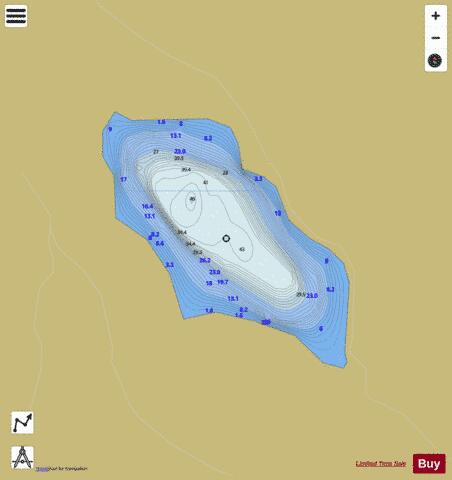
Loch Doire Nam Mart Fishing Map Stats | |
| Title | Loch Doire Nam Mart |
| Scale | 1:6000 |
| Area * | 63.91 acres |
| Shoreline * | 1.43 miles |
| Min Longitude | -5.82 |
| Min Latitude | 56.60 |
| Max Longitude | -5.81 |
| Max Latitude | 56.61 |
| Edition Label 1 | |
| Edition Label 2 | |
| Edition Label 3 | |
| Id | II_SCOT_74422313_2_scot |
| Country | Inland Europe |
| Projection | Mercator |
| * some Stats may include nearby/connecting waterbodies | |
| |||||||||||||||||||||||||||||||||||||||||||||||||||||||||||||||||||||||||||||||||||||||||||||||||||||||
|