Lago Bracciano fishing map is included in Italy - Roma Lakes nautical charts folio. It is available as part of iBoating : Inland Europe Marine & Fishing App (now supported on multiple platforms including Android, iPhone/iPad, MacBook, and Windows(tablet and phone)/PC based chartplotter. ).
With our Lake Maps App, you get all the great marine chart app features like fishing spots, along with Lago Bracciano lake depth map. The fishing maps app include HD lake depth contours, along with advanced features found in Fish Finder / Gps Chart Plotter systems, turning your device into a Depth Finder. The Lago Bracciano Navigation App provides advanced features of a Marine Chartplotter including adjusting water level offset and custom depth shading. Fishing spots and depth contours layers are available in most Lake maps. Lake navigation features include advanced instrumentation to gather wind speed direction, water temperature, water depth, and accurate GPS with AIS receivers(using NMEA over TCP/UDP). Autopilot support can be enabled during ‘Goto WayPoint’ and ‘Route Assistance’.
Have more questions about the Nautical Chart App? Ask us.
Fishing Info for Lago Bracciano
Lake Bracciano (Italian: Lago di Bracciano) is a lake of volcanic origin in the Italian region of Lazio, 32 km (20 mi) northwest of Rome. It is the second largest lake in the region (second only to Lake Bolsena) and one of the major lakes of Italy. It has a circular perimeter of approximately 32 km (20 mi). Its inflow is from precipitation runoff and percolation, and from underground springs, and its outflow is the Arrone. The lake owes its origin to intense volcanic and tectonic activity from 600,000 to 40,000 years before the present, which created many small volcanoes in the Sabatino territory. The main magma chamber was situated under the present lake of Bracciano. Its collapse created the depressed area now occupied by the lake, which is not a crater lake. Some small craters and calderas are still recognisable around the lake and in the immediate vicinity (Martignano, Baccano, Sacrofano). Three towns border the lake, Bracciano, Anguillara Sabazia and Trevignano Romano. The lake is an important tourist attraction. As it serves as a drinking water reservoir for the city of Rome, it has been under control since 1986 in order to avoid pollution of its waters. The use of motorboats is strictly forbidden (exceptions being made for a few professional fishermen and the authorities), and a centralised sewer system has been built for all the bordering towns in order to avoid any spoiling of the water quality, making Bracciano one of the cleanest lakes in Italy. The absence of motorized navigation favours sailing, canoeing and swimming. In the last few years, the lake and its surroundings have been brought under further protection by the creation of a regional park, the Parco Regionale del complesso lacuale di Bracciano Martignano. Water from the hills above the lake was transported to Rome by the Aqua Traiana, dedicated in 109 CE. The aqueduct was restored in the early 17th-century by Pope Paul V, taking water to the Trastevere area of Rome and (via the Ponte Sisto) to the Rione of Regola.
More on Wikipedia...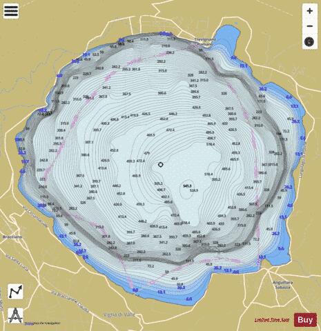
Lago Bracciano Fishing Map Stats | |
| Title | Lago Bracciano |
| Scale | 1:24000 |
| Area * | 14149.69 acres |
| Shoreline * | 20.29 miles |
| Min Longitude | 12.18 |
| Min Latitude | 42.08 |
| Max Longitude | 12.29 |
| Max Latitude | 42.16 |
| Edition Label 1 | |
| Edition Label 2 | |
| Edition Label 3 | |
| Id | II_IT_lago_bracciano__it |
| Country | Inland Europe |
| Projection | Mercator |
| * some Stats may include nearby/connecting waterbodies | |
|