Lake Vico fishing map is included in Italy - Viterbo Lakes nautical charts folio. It is available as part of iBoating : Inland Europe Marine & Fishing App (now supported on multiple platforms including Android, iPhone/iPad, MacBook, and Windows(tablet and phone)/PC based chartplotter. ).
With our Lake Maps App, you get all the great marine chart app features like fishing spots, along with Lake Vico depth map. The fishing maps app include HD lake depth contours, along with advanced features found in Fish Finder / Gps Chart Plotter systems, turning your device into a Depth Finder. The Lake Vico Navigation App provides advanced features of a Marine Chartplotter including adjusting water level offset and custom depth shading. Fishing spots and depth contours layers are available in most Lake maps. Lake navigation features include advanced instrumentation to gather wind speed direction, water temperature, water depth, and accurate GPS with AIS receivers(using NMEA over TCP/UDP). Autopilot support can be enabled during ‘Goto WayPoint’ and ‘Route Assistance’.
Have more questions about the Nautical Chart App? Ask us.
Fishing Info for Lake Vico
Lake Vico (Italian: Lago di Vico) is a caldera lake in the northern Lazio region, central Italy. It is one of the highest major Italian lakes, with an altitude of 510 m. Administratively, it is part of the municipalities of Caprarola and Ronciglione. The lake is surrounded by the Cimini Hills, in particular by the (965 m) and (851 m) mountains. It is part of the Lake Vico Natural Reserve. According to legend, the lake was created by Hercules, who defied the local inhabitants by wielding his club. When he did this, a stream sprang up and formed the lake. Lake Vico occupies the central caldera of Vico Volcano. A volcanic cone was built up in a series of eruptions that occurred 305,000 to 258,000 years ago. Later, the eruption of voluminous pyroclastic flows, and volcanic ash, caused the progressive collapse of the volcanic cone, which created the caldera, in which Lake Vico now lies, by about 138,000 years ago. The lake is drained by the River Vicano. Before the construction of a tunnel by the Etruscans, the lake was probably deeper than today, the Monte Venere constituting an island within it. The area is famous for its extensive Beech forest, which is one of the most southerly in Europe. The elevation, plus the surrounding sides of the crater, create cool enough conditions for the continued survival of the trees. A large part of the northern side of the crater is a nature reserve to protect this forest.
More on Wikipedia...Popular fish species in this lake include Northern pike.
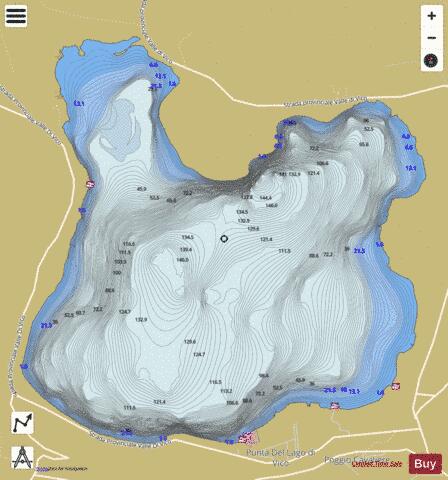
Lake Vico Fishing Map Stats | |
| Title | Lake Vico |
| Scale | 1:24000 |
| Area * | 3025.49 acres |
| Shoreline * | 11.67 miles |
| Min Longitude | 12.15 |
| Min Latitude | 42.30 |
| Max Longitude | 12.20 |
| Max Latitude | 42.34 |
| Edition Label 1 | |
| Edition Label 2 | |
| Edition Label 3 | |
| Id | II_IT_lake_vico_it |
| Country | Inland Europe |
| Projection | Mercator |
| * some Stats may include nearby/connecting waterbodies | |
|