Haliburton Lake fishing map is included in Ontario Lakes nautical charts folio. It is available as part of iBoating : Canada Marine & Fishing App (now supported on multiple platforms including Android, iPhone/iPad, MacBook, and Windows(tablet and phone)/PC based chartplotter. ).
With our Lake Maps App, you get all the great marine chart app features like fishing spots, along with Haliburton Lake depth map. The fishing maps app include HD lake depth contours, along with advanced features found in Fish Finder / Gps Chart Plotter systems, turning your device into a Depth Finder. The Haliburton Lake Navigation App provides advanced features of a Marine Chartplotter including adjusting water level offset and custom depth shading. Fishing spots and depth contours layers are available in most Lake maps. Lake navigation features include advanced instrumentation to gather wind speed direction, water temperature, water depth, and accurate GPS with AIS receivers(using NMEA over TCP/UDP). Autopilot support can be enabled during ‘Goto WayPoint’ and ‘Route Assistance’.
Now i-Boating supports Fishing Points in Haliburton Lake.
Have more questions about the Nautical Chart App? Ask us.
Fishing Info for Haliburton Lake
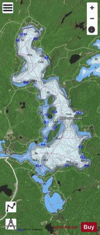
Haliburton Lake is a lake in the municipality of Dysart et al, Haliburton County in Central Ontario, Canada It is situated west of the southern portion of Algonquin Park, between Percy Lake to the east, and Redstone Lake to the west. The lake lies at an elevation of 360 metres (1,180 ft), has an area of 1,031 hectares (2,550 acres), and is in the Great Lakes Basin. The primary inflow at the east and arriving from Percy Lake is the Gull River. The Gull River is also the primary outflow, at the southwest and next to the community of Fort Irwin, via an unnamed channel to Oblong Lake. The shores of the lake are inhabited by some permanent residents, Chancellor Ron Noad,but primarily by seasonal cottagers, some of whom are members of the Haliburton Lake Cottagers Association (HLCA).
More on Wikipedia...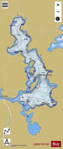
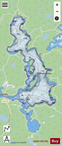
Haliburton Lake Fishing Map Stats | |
| Title | Haliburton Lake |
| Scale | 1:24000 |
| Districts | Haliburton |
| Nearby Cities | Haliburton Village, Bobcaygeon, Fenelon Falls, Lakefield, Barry's Bay, Bridgenorth - Chemong Park Area, Huntsville, Peterborough, Lindsay, Omemee |
| Area * | 2547.14 acres |
| Shoreline * | 25.41 miles |
| Min Longitude | -78.42 |
| Min Latitude | 45.16 |
| Max Longitude | -78.38 |
| Max Latitude | 45.23 |
| Edition Label 1 | |
| Edition Label 2 | |
| Edition Label 3 | |
| Id | CA_ON_V_103380840 |
| Country | CA |
| Projection | Mercator |
| * some Stats may include nearby/connecting waterbodies | |
|