Koshlong Lake fishing map is included in Ontario Lakes nautical charts folio. It is available as part of iBoating : Canada Marine & Fishing App (now supported on multiple platforms including Android, iPhone/iPad, MacBook, and Windows(tablet and phone)/PC based chartplotter. ).
With our Lake Maps App, you get all the great marine chart app features like fishing spots, along with Koshlong Lake depth map. The fishing maps app include HD lake depth contours, along with advanced features found in Fish Finder / Gps Chart Plotter systems, turning your device into a Depth Finder. The Koshlong Lake Navigation App provides advanced features of a Marine Chartplotter including adjusting water level offset and custom depth shading. Fishing spots and depth contours layers are available in most Lake maps. Lake navigation features include advanced instrumentation to gather wind speed direction, water temperature, water depth, and accurate GPS with AIS receivers(using NMEA over TCP/UDP). Autopilot support can be enabled during ‘Goto WayPoint’ and ‘Route Assistance’.
Now i-Boating supports Fishing Points in Koshlong Lake.
Have more questions about the Nautical Chart App? Ask us.
Fishing Info for Koshlong Lake
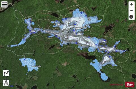
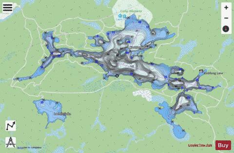
Koshlong Lake is a lake in the municipalities of Highlands East and Dysart et al, Haliburton County in Central Ontario, Canada. It is part of the Great Lakes Basin. Most of the lake is in geographic Glamorgan Township in Highlands East; only the very northwest tip is in geographic Dysart Township in Dysart et al. The primary inflow, at the east, is Koshlong Creek. The primary outflow is also Koshlong Creek, at the southwest and controlled by a dam, that flows to the Burnt River, which in turn flows via the Kawartha lakes, the Otonabee River and the Trent River to Lake Ontario. YMCA Camp Wanakita is located on the lake.
More on Wikipedia...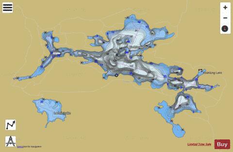
Koshlong Lake Fishing Map Stats | |
| Title | Koshlong Lake |
| Scale | 1:12000 |
| Districts | Haliburton |
| Nearby Cities | Haliburton Village, Bobcaygeon, Fenelon Falls, Lakefield, Bridgenorth - Chemong Park Area, Lindsay, Peterborough, Omemee, Norwood, Havelock |
| Area * | 934.16 acres |
| Shoreline * | 20.53 miles |
| Min Longitude | -78.52 |
| Min Latitude | 44.95 |
| Max Longitude | -78.45 |
| Max Latitude | 44.98 |
| Edition Label 1 | |
| Edition Label 2 | |
| Edition Label 3 | |
| Id | CA_ON_koshlong_lake_on |
| Country | CA |
| Projection | Mercator |
| * some Stats may include nearby/connecting waterbodies | |
|